IMAGES TAKEN NEAR TO
Calne Close, WIRRAL, CH61 4YB
Introduction
This page details the photographs taken nearby to Calne Close, CH61 4YB by members of the Geograph project.
The Geograph project started in 2005 with the aim of publishing, organising and preserving representative images for every square kilometre of Great Britain, Ireland and the Isle of Man.

There are currently over 7.5m images from over14,400 individuals and you can help contribute to the project by visiting https://www.geograph.org.uk
Image Map (Loading...)


Getting Data...Please wait
Leaflet Map data © OpenStreetMap
Images are licensed for reuse under creativecommons.org/licenses/by-sa/2.0
Notes
- Clicking on the map will re-center to the selected point.
- The higher the marker number, the further away the image location is from the centre of the postcode.
Image Listing (4 Images Found)
Images are licensed for reuse under creativecommons.org/licenses/by-sa/2.0
Image
Details
Distance
2
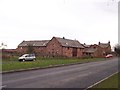
Mill Barn, Irby Hill Farm
Barn Conversions
Image: © Sue Morgan
Taken: 11 Feb 2006
0.23 miles
3
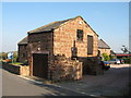
Irby Hill Farm, Irby Mill Hill Road
Converted barn at Irby Hill Farm, one of many conversions of the red sandstone buildings on the site of the original farm.
Image: © Sue Adair
Taken: 23 Oct 2007
0.24 miles