IMAGES TAKEN NEAR TO
Oaklea Road, WIRRAL, CH61 3US
Introduction
This page details the photographs taken nearby to Oaklea Road, CH61 3US by members of the Geograph project.
The Geograph project started in 2005 with the aim of publishing, organising and preserving representative images for every square kilometre of Great Britain, Ireland and the Isle of Man.

There are currently over 7.5m images from over14,400 individuals and you can help contribute to the project by visiting https://www.geograph.org.uk
Image Map (Loading...)


Getting Data...Please wait
Leaflet Map data © OpenStreetMap
Images are licensed for reuse under creativecommons.org/licenses/by-sa/2.0
Notes
- Clicking on the map will re-center to the selected point.
- The higher the marker number, the further away the image location is from the centre of the postcode.
Image Listing (11 Images Found)
Images are licensed for reuse under creativecommons.org/licenses/by-sa/2.0
Image
Details
Distance
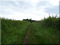
1
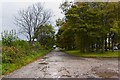
The old road is used as a lay-by by default
Image: © Ian Greig
Taken: 22 Sep 2017
0.11 miles
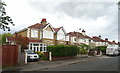
2
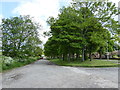
Off Thingwell Road, Irby
Between the road and the field there is an avenue of trees and parking space.
Image: © Eirian Evans
Taken: 23 May 2016
0.11 miles
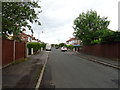
3
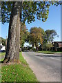
Thingwall Road
Travelling from Irby to Thingwall.
Image: © J Scott
Taken: 11 Oct 2010
0.14 miles
4
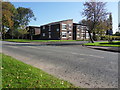
Close Junction
Thingwall Road at the junction with Dane Close, Thingwall.
Image: © J Scott
Taken: 11 Oct 2010
0.15 miles
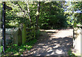
8
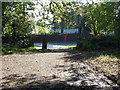
Entrance To Footpath 27
Vehicle access to footpath 27 - Arrowe Brook Lane from Thingwall Road via Neilson's Plantation.
Image: © J Scott
Taken: 11 Oct 2010
0.20 miles
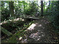
9
Footpath 27
Access to footpath between Thingwall Road and Arrowe Brook Lane through Neilson's Plantation.
Image: © J Scott
Taken: 11 Oct 2010
0.21 miles
10
Brook Bridge
Footpath 27 from Arrowe Brook Lane approaching Thingwall Road. Footbridge over dry Arrowe Brook.
Image: © J Scott
Taken: 11 Oct 2010
0.23 miles