IMAGES TAKEN NEAR TO
Station Road, WIRRAL, CH61 1DG
Introduction
This page details the photographs taken nearby to Station Road, CH61 1DG by members of the Geograph project.
The Geograph project started in 2005 with the aim of publishing, organising and preserving representative images for every square kilometre of Great Britain, Ireland and the Isle of Man.

There are currently over 7.5m images from over14,400 individuals and you can help contribute to the project by visiting https://www.geograph.org.uk
Image Map (Loading...)


Getting Data...Please wait
Leaflet Map data © OpenStreetMap
Images are licensed for reuse under creativecommons.org/licenses/by-sa/2.0
Notes
- Clicking on the map will re-center to the selected point.
- The higher the marker number, the further away the image location is from the centre of the postcode.
Image Listing (10 Images Found)
Images are licensed for reuse under creativecommons.org/licenses/by-sa/2.0
Image
Details
Distance
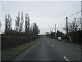
1
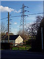
High Voltage
Bungalow alongside Station Road, neighbours an extra high voltage power cable pylon.
Image: © J Scott
Taken: 24 Nov 2010
0.01 miles
2
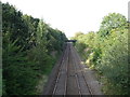
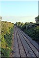
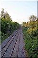
Railway towards Bidston
From the bridge on Station Road.
The site of Storeton Station.
Image: © JThomas
Taken: 14 Sep 2019
0.05 miles
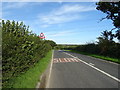
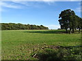
5
The Borderlands Line, Barnston
Facing towards Heswall.
Image: © El Pollock
Taken: 28 May 2012
0.06 miles
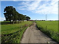
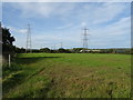
8
Grazing near Ley Farm
Towards New Hey Covert.
Image: © JThomas
Taken: 14 Sep 2019
0.12 miles
9
The Borderlands Line, Barnston
The site of the former Storeton railway station. Facing towards Upton.
Image: © El Pollock
Taken: 28 May 2012
0.15 miles
10
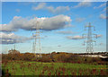
Power Field
Extra High Voltage power cables cross pasture land alongside Station Road, near Storeton.
Image: © J Scott
Taken: 24 Nov 2010
0.17 miles