IMAGES TAKEN NEAR TO
Private Drive, WIRRAL, CH61 1DE
Introduction
This page details the photographs taken nearby to Private Drive, CH61 1DE by members of the Geograph project.
The Geograph project started in 2005 with the aim of publishing, organising and preserving representative images for every square kilometre of Great Britain, Ireland and the Isle of Man.

There are currently over 7.5m images from over14,400 individuals and you can help contribute to the project by visiting https://www.geograph.org.uk
Image Map (Loading...)


Getting Data...Please wait
Leaflet Map data © OpenStreetMap
Images are licensed for reuse under creativecommons.org/licenses/by-sa/2.0
Notes
- Clicking on the map will re-center to the selected point.
- The higher the marker number, the further away the image location is from the centre of the postcode.
Image Listing (10 Images Found)
Images are licensed for reuse under creativecommons.org/licenses/by-sa/2.0
Image
Details
Distance
1
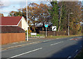
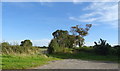
Private Drive
Private Drive off Storeton Lane, Barnston, leading to Overdale Avenue.
Image: © J Scott
Taken: 24 Nov 2010
0.09 miles
2
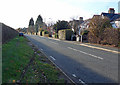
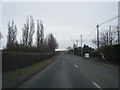
Through Road
Storeton Lane, leading in direction of A551 junction, Barnston.
Image: © J Scott
Taken: 24 Nov 2010
0.11 miles
4
A dreary helipad, Murrayfield Hospital
It is unlikely that many helicopters land here - the hospital is private and doesn't deal with emergencies. It may be required for the consultants though - the hospital owners, Spire, list almost a hundred as being available at Murrayfield, and the majority of them spread their workloads between three our four Spire premises.
Licences are not required for helipads that do not anticipate being used for more than 28 days a year. On the other hand, however, there is a four year old document by the Civil Aviation Authority which stretches to 135 pages, detailing the dos and don'ts for hospital helipads. Whilst it must obviously only apply to the 28 day plus variety, it still seems excessive; I often think life would be simpler if our document authors had had to study the Highway Code as part of their training.
This pad seems quite straightforward: a cross to show you're at the hospital; four normal lamps to light up the landing area; and an upward-pointing red/green light at each corner of the square. The green obviously indicates it's good to land and the red that it's not. I would hope that the helicopters themselves also have lights on their tops, just in case the helipad is playing up and another one tries to land on them.
Image: © Ian Dodds
Taken: 12 Apr 2023
0.14 miles
5
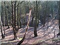
Barnston Dale
More on this at http://www.barnstonvillage.info/bvcamp.htm
Image: © Peter Craine
Taken: 17 Feb 2007
0.17 miles
6
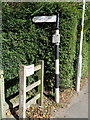
Old Direction Sign - Signpost by Storeton Lane, Barnston
Ball finial - 1 arm; Wirral Footpath post by the UC road, in parish of Heswall (Wirral District), North East side of Storeton Lane, Barnston.
Column inscription reads:-
: WIRRAL FOOTPATHS ETC PRESERVATION SOCIETY BY PERMISSION OF THE COUNCIL :
Maker:-
: W H SMITH / WHITCHURCH / SALOP :
Merseyside HER.
https://www.heritagegateway.org.uk/Gateway/Results_Single.aspx?uid=3314359&resourceID=1970
Surveyed
Milestone Society National ID: CH_SJ2883A
Image: © John S Turner
Taken: 17 Sep 2016
0.19 miles
9
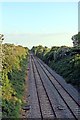
The Borderlands Line, Barnston
Facing towards Heswall.
Image: © El Pollock
Taken: 28 May 2012
0.24 miles
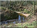
10
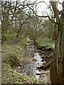
Prenton Brook
Prenton Brook is a short river starting near Pensby and flowing to a confluence with the River Fender near Prenton. The photograph was taken looking towards Barnston Dale, shortly before the brook starts meandering.
Image: © David Quinn
Taken: 23 Mar 2008
0.25 miles