IMAGES TAKEN NEAR TO
Barnsdale Avenue, WIRRAL, CH61 1BD
Introduction
This page details the photographs taken nearby to Barnsdale Avenue, CH61 1BD by members of the Geograph project.
The Geograph project started in 2005 with the aim of publishing, organising and preserving representative images for every square kilometre of Great Britain, Ireland and the Isle of Man.

There are currently over 7.5m images from over14,400 individuals and you can help contribute to the project by visiting https://www.geograph.org.uk
Image Map
Images are licensed for reuse under creativecommons.org/licenses/by-sa/2.0
Notes
- Clicking on the map will re-center to the selected point.
- The higher the marker number, the further away the image location is from the centre of the postcode.
Image Listing (10 Images Found)
Images are licensed for reuse under creativecommons.org/licenses/by-sa/2.0
Image
Details
Distance
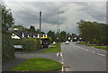
3
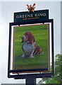
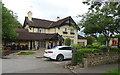
Sign for the Basset Hound, Thingwall
See Image] for context.
Image: © JThomas
Taken: 15 Jun 2019
0.11 miles
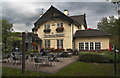
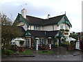
5
The Basset Hound, Thingwall
On Barnston Road.
Image: © JThomas
Taken: 15 Jun 2019
0.12 miles
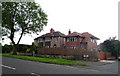
7
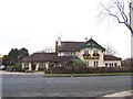
The Basset Hound
The Basset Hound pub and restaurant, Thingwall
Image: © Sue Morgan
Taken: 11 Feb 2006
0.15 miles
8
The Thing in Thingwall, Cross Hill
During the 10th century, Wirral was a Viking mini-state with its own parliament (the Thing, or Ting). This was located on Cross Hill, across the main road from the reservoirs. Thingwall means 'assembly place'. Today, there is no indication there of its historical significance.
Image: © Peter Craine
Taken: 17 Feb 2007
0.20 miles
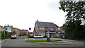
10
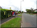
Bus stop and shelter on Barnston Road, Thingwall
The A551.
Image: © JThomas
Taken: 15 Jun 2019
0.24 miles