IMAGES TAKEN NEAR TO
Woodlands Drive, WIRRAL, CH61 1AP
Introduction
This page details the photographs taken nearby to Woodlands Drive, CH61 1AP by members of the Geograph project.
The Geograph project started in 2005 with the aim of publishing, organising and preserving representative images for every square kilometre of Great Britain, Ireland and the Isle of Man.

There are currently over 7.5m images from over14,400 individuals and you can help contribute to the project by visiting https://www.geograph.org.uk
Image Map (Loading...)


Getting Data...Please wait
Leaflet Map data © OpenStreetMap
Images are licensed for reuse under creativecommons.org/licenses/by-sa/2.0
Notes
- Clicking on the map will re-center to the selected point.
- The higher the marker number, the further away the image location is from the centre of the postcode.
Image Listing (10 Images Found)
Images are licensed for reuse under creativecommons.org/licenses/by-sa/2.0
Image
Details
Distance
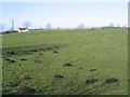
1
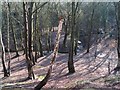
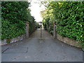
Barnston Dale
More on this at http://www.barnstonvillage.info/bvcamp.htm
Image: © Peter Craine
Taken: 17 Feb 2007
0.12 miles
2
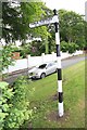
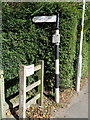
Old Direction Sign - Signpost by the A551, Barnston Road, Heswall
Ball finial - 1 arm; Wirral Footpath post by the A551, Barnston Road, by the junction with Holmwood Drive, in parish of Thornton (Wirral District), Barnston.
Surveyed
Milestone Society National ID: CH_SJ2884.
Image: © Milestone Society
Taken: Unknown
0.14 miles
3
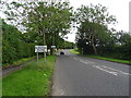
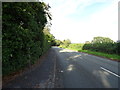
Entering Barnston Village
On Barnston Road (A551).
Image: © JThomas
Taken: 15 Jun 2019
0.16 miles

7
Old Direction Sign - Signpost by Storeton Lane, Barnston
Ball finial - 1 arm; Wirral Footpath post by the UC road, in parish of Heswall (Wirral District), North East side of Storeton Lane, Barnston.
Column inscription reads:-
: WIRRAL FOOTPATHS ETC PRESERVATION SOCIETY BY PERMISSION OF THE COUNCIL :
Maker:-
: W H SMITH / WHITCHURCH / SALOP :
Merseyside HER.
https://www.heritagegateway.org.uk/Gateway/Results_Single.aspx?uid=3314359&resourceID=1970
Surveyed
Milestone Society National ID: CH_SJ2883A
Image: © John S Turner
Taken: 17 Sep 2016
0.20 miles
8
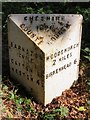
Old Milepost by the A551, Barnston Road, Wirral
Cast iron post by the A551, in parish of HESWALL (WIRRAL District), opposite Tree Tops, Barnston, in hedge, on East side of road. Cast iron CCC1896, erected by the County Council in the 19th century.
Inscription reads:-
: BARNSTON / ¼ MILE / GAYTON 1¾ / NESTON 4½ : : CHESHIRE / 1896 / COUNTY COUNCIL : : WOODCHURCH / 2 MILES / BIRKENHEAD 6 :
Maker:-
: W H SMITH & CO / MAKER / WHITCHURCH :
Milestone Society National ID: CH_BHNS06
Image: © John S Turner
Taken: 7 Sep 2016
0.20 miles
10
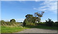
The Thing in Thingwall, Cross Hill
During the 10th century, Wirral was a Viking mini-state with its own parliament (the Thing, or Ting). This was located on Cross Hill, across the main road from the reservoirs. Thingwall means 'assembly place'. Today, there is no indication there of its historical significance.
Image: © Peter Craine
Taken: 17 Feb 2007
0.24 miles