IMAGES TAKEN NEAR TO
Dawpool Farm, Station Road, WIRRAL, CH61 0HR
Introduction
This page details the photographs taken nearby to Dawpool Farm, Station Road, CH61 0HR by members of the Geograph project.
The Geograph project started in 2005 with the aim of publishing, organising and preserving representative images for every square kilometre of Great Britain, Ireland and the Isle of Man.

There are currently over 7.5m images from over14,400 individuals and you can help contribute to the project by visiting https://www.geograph.org.uk
Image Map (Loading...)


Getting Data...Please wait
Leaflet Map data © OpenStreetMap
Images are licensed for reuse under creativecommons.org/licenses/by-sa/2.0
Notes
- Clicking on the map will re-center to the selected point.
- The higher the marker number, the further away the image location is from the centre of the postcode.
Image Listing (37 Images Found)
Images are licensed for reuse under creativecommons.org/licenses/by-sa/2.0
Image
Details
Distance
1
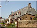
Cottage, Thurstaston
Cottage built of the local sandstone on Station Road, Thurstaston Village.
Image: © Sue Adair
Taken: 10 May 2006
0.02 miles
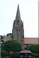
5
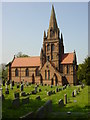
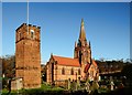
St Bartholomew's Church, Thurstaston
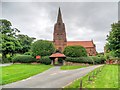
'Turstanetone' is recorded in the Domesday Book. The earliest mention of a Church occurs around 1125 but other evidence suggests that one may have existed in Saxon times. The Norman Church endured for many hundreds of years and was eventually taken down in 1820 and a second edifice completed in 1824. This was a very plain stone building and in 1871, the replacement of this second Church was approved and the executors of Joseph Hegan of Dawpool set apart £4,500 for a new church erected to his memory by his two daughters and consecrated by William Stubbs, Bishop of Chester, on the 7th January 1886. Designed by J. Loughborough Pearson R.A. a splendid example of the Victorian revival of mid-gothic architecture, being of late 13th century character and built entirely of local sandstone. Although nothing remains of the earlier Norman church, the tower of the second one still stands in the churchyard and the sandstone of the building was used to construct a wall enclosing the new churchyard.
Image: © Sue Adair
Taken: 10 May 2006
0.09 miles
6
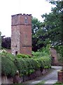
Bell Tower, Thurstaston
The bell tower of St. Bartholomew's Church. Situated down the lane to the right-hand side of the church, when viewed from Station Road junction.
Image: © El Pollock
Taken: 18 Jul 2009
0.09 miles
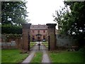
7

Gateway to Thurstaston Hall
The gates to Thurstaston Hall, parts of which date from 1350, although most of the current building dates from between 1680 and 1835. A ghostly "white lady" is said to haunt the Hall.
Image: © Eirian Evans
Taken: 12 Sep 2009
0.09 miles
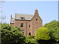
9
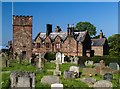
Thurstaston Hall.
Thurstaston Hall seen from the adjacent graveyard.
Image: © Peter McDermott
Taken: 25 May 2017
0.10 miles
10
The Church of St Bartholomew, Thurstaston
The Church of St Bartholomew, in the village of Thurstaston, is recorded in the National Heritage List for England as a designated Grade II* listed building (English Heritage Building ID: 215639 http://www.britishlistedbuildings.co.uk/en-215639-church-of-st-bartholomew-#.VfH9PHmFOHs British Listed Buildings). The current church which is built in red sandstone, has a tiled roof and a tower with a spire. It was consecrated in 1886.
The lychgate was erected in 1900, in memory of Thomas Henry Ismay of Dawpool.
Image: © David Dixon
Taken: 6 Sep 2015
0.10 miles