IMAGES TAKEN NEAR TO
Thurstaston Road, WIRRAL, CH61 0HG
Introduction
This page details the photographs taken nearby to Thurstaston Road, CH61 0HG by members of the Geograph project.
The Geograph project started in 2005 with the aim of publishing, organising and preserving representative images for every square kilometre of Great Britain, Ireland and the Isle of Man.

There are currently over 7.5m images from over14,400 individuals and you can help contribute to the project by visiting https://www.geograph.org.uk
Image Map (46 Images)


Getting Data...Please wait
Leaflet Map data © OpenStreetMap
Images are licensed for reuse under creativecommons.org/licenses/by-sa/2.0
Notes
- Clicking on the map will re-center to the selected point.
- The higher the marker number, the further away the image location is from the centre of the postcode.
Image Listing (46 Images Found)
Images are licensed for reuse under creativecommons.org/licenses/by-sa/2.0
Image
Details
Distance
1
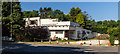
Heatherlands
The Heatherlands restaurant and banqueting suit.
Image: © Peter McDermott
Taken: 25 May 2017
0.01 miles
2
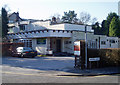
Heatherlands Court
Restaurant and Banqueting Suit corner of Thurstaston Road and School Lane.
Image: © J Scott
Taken: 13 Feb 2008
0.02 miles
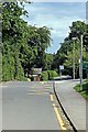
3
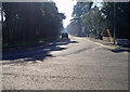
Towards Thurstaston
Thurstaston Road continues towards the A540 Telegraph Road.
Image: © J Scott
Taken: 13 Feb 2008
0.04 miles
4
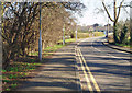
Road To Irby
Thurstaston Road leading into Irby village.
Image: © J Scott
Taken: 13 Feb 2008
0.07 miles
5
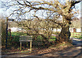
Private Road
Road off School Lane to Benty Farm at Thurstaston Common.
Image: © J Scott
Taken: 13 Feb 2008
0.10 miles
6
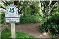
Entrance to Thurstaston Common
Entrance at the southeast corner of the common.
Image: © Jeff Buck
Taken: 18 Jul 2019
0.11 miles
8
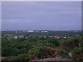
View from Thurstaston Hill
To the rear of the photographer's position, a perhaps more wonderful view of the Dee Estuary and the North Wales coast can be enjoyed. However this view is equally interesting as features of the Liverpool skyline can be observed.
To the left is Goodison Park, and to the right the Anglican Cathedral. The building among the trees is Arrowe Park Hospital. The church near the Radio City Tower in the shot, is Oxton St Saviour's.
Filedate-time: 20080703-212506
The larger version of this file (2600*2080 Pixel) can be found at this link:-
http://farm4.static.flickr.com/3079/2636365454_eab855989c_o.jpg
Image: © Mihacel
Taken: 3 Jul 2008
0.12 miles
9
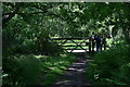
Gated Access
Footpath to the south of Benty Farm in Thurstaston Common.
Image: © J Scott
Taken: 1 Jun 2007
0.15 miles
10
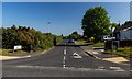
School Lane, Thurstaston
Viewed from the entrance to Thurstaston Common.
Image: © El Pollock
Taken: 12 Jun 2012
0.15 miles