IMAGES TAKEN NEAR TO
Thurstaston Road, WIRRAL, CH61 0HF
Introduction
This page details the photographs taken nearby to Thurstaston Road, CH61 0HF by members of the Geograph project.
The Geograph project started in 2005 with the aim of publishing, organising and preserving representative images for every square kilometre of Great Britain, Ireland and the Isle of Man.

There are currently over 7.5m images from over14,400 individuals and you can help contribute to the project by visiting https://www.geograph.org.uk
Image Map
Images are licensed for reuse under creativecommons.org/licenses/by-sa/2.0
Notes
- Clicking on the map will re-center to the selected point.
- The higher the marker number, the further away the image location is from the centre of the postcode.
Image Listing (27 Images Found)
Images are licensed for reuse under creativecommons.org/licenses/by-sa/2.0
Image
Details
Distance
2
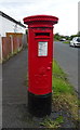
George V postbox on Thurstaston Road, Irby
Postbox No. CH61 485.
See Image] for context.
Image: © JThomas
Taken: 15 Jun 2019
0.07 miles
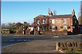
3
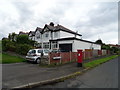
Houses on Thurstaston Road, Irby
Showing position of Postbox No. CH61 485.
See Image] for postbox.
Image: © JThomas
Taken: 15 Jun 2019
0.08 miles
8
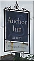
Sign for the Anchor Inn at Irby
See Image] for context.
Image: © JThomas
Taken: 15 Jun 2019
0.19 miles
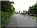
9
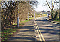
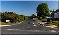
Road To Irby
Thurstaston Road leading into Irby village.
Image: © J Scott
Taken: 13 Feb 2008
0.19 miles
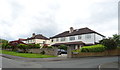
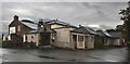
10
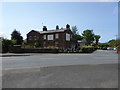
The Anchor Inn, Irby
On Thurstaston Road.
Image: © Eirian Evans
Taken: 23 May 2016
0.20 miles