IMAGES TAKEN NEAR TO
Linden Court, DEESIDE, CH5 4WA
Introduction
This page details the photographs taken nearby to Linden Court, CH5 4WA by members of the Geograph project.
The Geograph project started in 2005 with the aim of publishing, organising and preserving representative images for every square kilometre of Great Britain, Ireland and the Isle of Man.

There are currently over 7.5m images from over14,400 individuals and you can help contribute to the project by visiting https://www.geograph.org.uk
Image Map
Images are licensed for reuse under creativecommons.org/licenses/by-sa/2.0
Notes
- Clicking on the map will re-center to the selected point.
- The higher the marker number, the further away the image location is from the centre of the postcode.
Image Listing (7 Images Found)
Images are licensed for reuse under creativecommons.org/licenses/by-sa/2.0
Image
Details
Distance

5
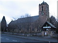
St Marks Church, Connahs Quay
Looking across the B5129 to St Marks parish church, Connahs Quay.
Image: © Phil Williams
Taken: 31 Dec 2005
0.18 miles
7
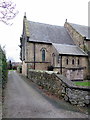
St Marks church Connahs Quay
The east end of St Marks church, Connahs Quay, There is an Ordnance Survey bench mark on the light-coloured corner of the church alongside the driveway - Image
Image: © John S Turner
Taken: 11 Jan 2019
0.25 miles