IMAGES TAKEN NEAR TO
Kings Road, DEESIDE, CH5 4UY
Introduction
This page details the photographs taken nearby to Kings Road, CH5 4UY by members of the Geograph project.
The Geograph project started in 2005 with the aim of publishing, organising and preserving representative images for every square kilometre of Great Britain, Ireland and the Isle of Man.

There are currently over 7.5m images from over14,400 individuals and you can help contribute to the project by visiting https://www.geograph.org.uk
Image Map
Images are licensed for reuse under creativecommons.org/licenses/by-sa/2.0
Notes
- Clicking on the map will re-center to the selected point.
- The higher the marker number, the further away the image location is from the centre of the postcode.
Image Listing (58 Images Found)
Images are licensed for reuse under creativecommons.org/licenses/by-sa/2.0
Image
Details
Distance
1
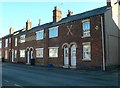
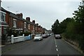
Terraced houses with fancy brickwork, Pen-y-Llan Street
Image: © Eirian Evans
Taken: 3 Feb 2012
0.09 miles
2
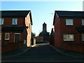
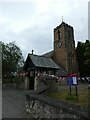
Lane to Osbourne Court from Pen-y-Llan Street
St Mary's Church at centre.
Image: © Eirian Evans
Taken: 3 Feb 2012
0.10 miles
3
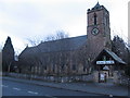
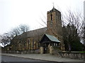
St Marks Church, Connahs Quay
Looking across the B5129 to St Marks parish church, Connahs Quay.
Image: © Phil Williams
Taken: 31 Dec 2005
0.11 miles

6

Date (1836) on St Mark's church, Connah's Quay
Image: © David Smith
Taken: 6 May 2023
0.14 miles
9
Dee View Road
Looking along Dee View Road off Church Street.
Image: © DS Pugh
Taken: 8 Aug 2020
0.15 miles
10
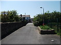
Footpath over the railway
Bridge over the Chester to Holyhead railway.
Image: © John Haynes
Taken: 22 May 2012
0.15 miles