IMAGES TAKEN NEAR TO
Glynne Street, DEESIDE, CH5 4RA
Introduction
This page details the photographs taken nearby to Glynne Street, CH5 4RA by members of the Geograph project.
The Geograph project started in 2005 with the aim of publishing, organising and preserving representative images for every square kilometre of Great Britain, Ireland and the Isle of Man.

There are currently over 7.5m images from over14,400 individuals and you can help contribute to the project by visiting https://www.geograph.org.uk
Image Map
Images are licensed for reuse under creativecommons.org/licenses/by-sa/2.0
Notes
- Clicking on the map will re-center to the selected point.
- The higher the marker number, the further away the image location is from the centre of the postcode.
Image Listing (30 Images Found)
Images are licensed for reuse under creativecommons.org/licenses/by-sa/2.0
Image
Details
Distance
1
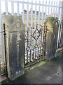
Southern gateposts for the demolished Custom House Lane CP School
This southern pair of gateposts have been left despite the demolition of the old Custom House Lane CP School. The council intend to build modern housing on the site, so it will be interesting to see if the gateposts survive. The hinges of the 'fancy' gate don't seem to match the hinge fittings of the post, so perhaps a plainer gate would have been there originally - see also Image
Image: © John S Turner
Taken: 1 Feb 2016
0.09 miles
2
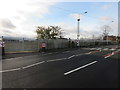
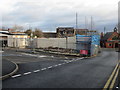
The site of Custom House Lane C.P. School, Connah's Quay
Looking across Mold Road towards the site of Custom House Lane County Primary School. The school was demolished some time ago and the council plan to build modern housing on the site.
Image: © John S Turner
Taken: 1 Feb 2016
0.10 miles
3
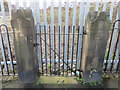
Northern gateposts for the demolished Custom House Lane CP School
This pair of gateposts have been left despite the demolition of the old Custom House Lane CP School. The council intend to build modern housing on the site, so it will be interesting to see if the gateposts survive. The plain gate seems more likely to be original by comparison with the southern gate - see Image
Image: © John S Turner
Taken: 1 Feb 2016
0.10 miles
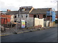
5
Demolishing the 'Old Dairy', Mold Road, Connah's Quay
The demolition of the 'Old Dairy' in Mold Road is well advanced, and the council intends to build housing on the site. #149-159 High Street are part of the same site and are also being demolished - see Image
Image: © John S Turner
Taken: 1 Feb 2016
0.17 miles
8
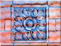
A design 'brick' in the side of the 'Old Dairy', Mold Road
This lovely old panel is/was in the side wall of the 'Old Dairy' in Mold Road, Connah's Quay. The building was in the process of being demolished when I took the photo, and the 'weird' special effect is caused by the safety netting that surrounded the remains of the building. Nevertheless, I thought it was worth recording something which represents the skill of, probably, one of the many local brick works. For the remains of the building, which will soon have disappeared completely, see Image
Image: © John S Turner
Taken: 1 Feb 2016
0.18 miles

10
The rear of #149-159 High Street from Mold Road
Looking across Mold Road at the rear of #149-159 High Street, which is in the process of being demolished. When the site is cleared the council intend to build modern housing.
Image: © John S Turner
Taken: 1 Feb 2016
0.19 miles