IMAGES TAKEN NEAR TO
Wesley Street, DEESIDE, CH5 4EE
Introduction
This page details the photographs taken nearby to Wesley Street, CH5 4EE by members of the Geograph project.
The Geograph project started in 2005 with the aim of publishing, organising and preserving representative images for every square kilometre of Great Britain, Ireland and the Isle of Man.

There are currently over 7.5m images from over14,400 individuals and you can help contribute to the project by visiting https://www.geograph.org.uk
Image Map
Images are licensed for reuse under creativecommons.org/licenses/by-sa/2.0
Notes
- Clicking on the map will re-center to the selected point.
- The higher the marker number, the further away the image location is from the centre of the postcode.
Image Listing (60 Images Found)
Images are licensed for reuse under creativecommons.org/licenses/by-sa/2.0
Image
Details
Distance

5
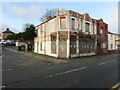
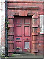
A once stylish building on the corner of Dean's Place/High Street
Looking across High Street, Connah's Quay towards the once stylish building on the corner with Dean's Place. #235, the un-painted red brick part of the building, is dated 1908 on the gable, and was once a bank. The rendered and white painted part is numbered 231 and 233 and was presumably once a shop.
Image: © John S Turner
Taken: 1 Feb 2016
0.08 miles
6
Front door of #235 High Street, Connah's Quay
The front door of the derelict #235 High Street, Connah's Quay. The gable of the building carries the date 1908, and old maps indicate that it was once a bank. For the entire building see Image
Image: © John S Turner
Taken: 1 Feb 2016
0.08 miles
7
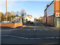
Maude Street, Connahs Quay
Looking across High Street towards Maude Street. At the end of Maude Street there is a public footpath across the main North Wales railway line, which should be used with caution.
Image: © John S Turner
Taken: 22 Nov 2013
0.11 miles
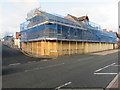
8
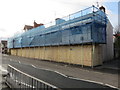
#149-159 High Street, Connah's Quay
This terrace of houses is in the process of being demolished by the council. They intend to build new housing on the site.
Image: © John S Turner
Taken: 1 Feb 2016
0.11 miles
9
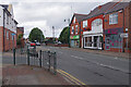
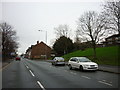
High Street, Connah's Quay
Looking along the dead straight High Street at Connah's Quay, part of the B5129. The B5126 leads off to the left towards Northop.
Image: © Stephen McKay
Taken: 11 Jul 2023
0.12 miles
10
#149-159 High Street, Connah's Quay and Mold Road
Looking across High Street, Connah's Quay towards #149-159. The terrace is in the process of being demolished, and the council plan to build modern housing on the site. Mold Road is along the side of the site, and there is an Ordnance Survey bench mark on the front of #149, which is now inaccessible behind the safety boards.
Image: © John S Turner
Taken: 1 Feb 2016
0.12 miles