IMAGES TAKEN NEAR TO
High Street, DEESIDE, CH5 4DD
Introduction
This page details the photographs taken nearby to High Street, CH5 4DD by members of the Geograph project.
The Geograph project started in 2005 with the aim of publishing, organising and preserving representative images for every square kilometre of Great Britain, Ireland and the Isle of Man.

There are currently over 7.5m images from over14,400 individuals and you can help contribute to the project by visiting https://www.geograph.org.uk
Image Map
Images are licensed for reuse under creativecommons.org/licenses/by-sa/2.0
Notes
- Clicking on the map will re-center to the selected point.
- The higher the marker number, the further away the image location is from the centre of the postcode.
Image Listing (81 Images Found)
Images are licensed for reuse under creativecommons.org/licenses/by-sa/2.0
Image
Details
Distance
1
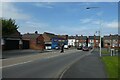
End of Wepre Drive
Looking towards the High Street in Shotton.
Image: © DS Pugh
Taken: 8 Aug 2020
0.04 miles

4
Wepre Drive
Looking along Wepre Drive near the High Street in Shotton.
Image: © DS Pugh
Taken: 8 Aug 2020
0.07 miles
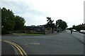
5
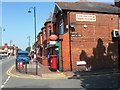
Wepre Post Office, 92 High Street, Connahs Quay
Looking across High Street to Wepre Post Office on the corner with Celtic Street.
Image: © John S Turner
Taken: 22 Nov 2013
0.07 miles

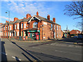
8
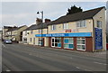
Cross Solicitors, 2 High Street, Connah's Quay
At the southeast end of High Street, near the Shotton boundary.
Image: © Jaggery
Taken: 22 Feb 2018
0.11 miles
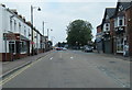
9
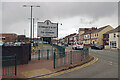
Entering Connah's Quay
This is the eastern end of Connah's Quay High Street, part of the B5129. The town is believed to take its name from a Joseph Connah an 18th century member of a local industrialist family.
Image: © Stephen McKay
Taken: 11 Jul 2023
0.12 miles
10
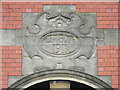
'Rehoboth 1911' plaque on The Salvation Army church
This plaque is high up on the front of what is now The Salvation Army church in Dee Road, Connah's Quay - http://www.salvationarmy.org.uk/connahs-quay Originally the building was the Rehoboth Congregational Chapel. See also Image
Image: © John S Turner
Taken: 1 Feb 2016
0.12 miles