IMAGES TAKEN NEAR TO
Kipling Close, DEESIDE, CH5 3UG
Introduction
This page details the photographs taken nearby to Kipling Close, CH5 3UG by members of the Geograph project.
The Geograph project started in 2005 with the aim of publishing, organising and preserving representative images for every square kilometre of Great Britain, Ireland and the Isle of Man.

There are currently over 7.5m images from over14,400 individuals and you can help contribute to the project by visiting https://www.geograph.org.uk
Image Map
Images are licensed for reuse under creativecommons.org/licenses/by-sa/2.0
Notes
- Clicking on the map will re-center to the selected point.
- The higher the marker number, the further away the image location is from the centre of the postcode.
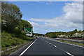
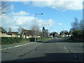
Image Listing (4 Images Found)
Images are licensed for reuse under creativecommons.org/licenses/by-sa/2.0
Image
Details
Distance
1
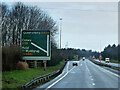
Ewloe Interchange (Junction 34), North Wales Expressway (A55)
Image: © David Dixon
Taken: 14 Feb 2022
0.07 miles
4
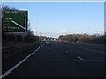
A55 going TOTSO at Ewloe
TOTSO in road engineering means "turn off to stay on". Here, A55 users must leave the main carriageway to continue on that route toward Holyhead.
Image: © Peter Whatley
Taken: 18 Jan 2011
0.23 miles