IMAGES TAKEN NEAR TO
Llys Gary Speed, DEESIDE, CH5 3FE
Introduction
This page details the photographs taken nearby to Llys Gary Speed, CH5 3FE by members of the Geograph project.
The Geograph project started in 2005 with the aim of publishing, organising and preserving representative images for every square kilometre of Great Britain, Ireland and the Isle of Man.

There are currently over 7.5m images from over14,400 individuals and you can help contribute to the project by visiting https://www.geograph.org.uk
Image Map
Images are licensed for reuse under creativecommons.org/licenses/by-sa/2.0
Notes
- Clicking on the map will re-center to the selected point.
- The higher the marker number, the further away the image location is from the centre of the postcode.
Image Listing (13 Images Found)
Images are licensed for reuse under creativecommons.org/licenses/by-sa/2.0
Image
Details
Distance


5
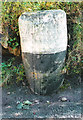
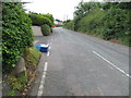
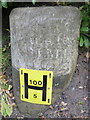
Old Milestone, Old Aston Hill (former A494), Aston
The milestone is located outside Merlewood under the hedge by the roadside on the south side of the road. Parish of Hawarden (Flintshire District).
Inscription reads:-
: To / Mold / 5 Miles : : To / the Ferry / 1 Mile :
Rivet benchmark on top.
('Ferry' refers to Queensferry, which was formerly Kingsferry, and before 1820, Lower Ferry.)
Milestone Society National ID: FLT_MDQF05
Image: © John Higgins
Taken: Unknown
0.18 miles
6
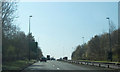
Old Aston Hill and a milestone
Looking up the by-passed Old Aston Hill. Before the A494 dual carriageway was built this used to be the main road from Ewloe down to Queensferry. The old milestone on the left dates to a time when horses and carts were the norm - the near side states: "Too Mold 5 Miles" Image, and the far side states: "To the Ferry 1 Mile" Image There is a rivet bench mark on top of the stone - Image
Image: © John S Turner
Taken: 25 Jun 2016
0.18 miles
7
Old milestone on Old Aston Hill - west face
This old milestone is on the south side of Old Aston Hill, which is now by-passed. This side of the stone states: "To the Ferry 1 Mile", a reference to Queensferry, which was formerly Kingsferry, and before 1820, Lower Ferry. For the west side of the stone see Image, and the roadside view Image There is a rivet bench mark on the top of the stone - Image, and the least said about the water hydrant plate the better.
Image: © John S Turner
Taken: 25 Jun 2016
0.18 miles
8
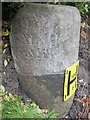
Old milestone on Old Aston Hill - east face
This old milestone is on the south side of Old Aston Hill, which is now by-passed. This side of the stone states: "Too Mold 5 Miles". See also the west face Image, and the roadside view Image There is a rivet bench mark on the top of the stone - Image, and the least said about the water hydrant plate the better.
Image: © John S Turner
Taken: 25 Jun 2016
0.18 miles
9
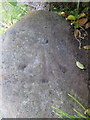
Rivet bench mark on a milestone on Old Aston Hill
This slightly weathered Ordnance Survey rivet bench mark is on top of the old milestone on Old Aston Hill - Image This road is now bypassed but once was the main road between Ewloe and Queensferry.
Image: © John S Turner
Taken: 25 Jun 2016
0.18 miles
10
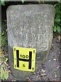
Old Milestone, Old Aston Hill (former A494), Aston
The milestone is located outside Merlewood under the hedge by the roadside on the south side of the road. Parish of Hawarden (Flintshire District).
Milestone Society National ID: FLT_MDQF05
Image: © John Turner
Taken: 1 Jun 2016
0.18 miles