IMAGES TAKEN NEAR TO
Mold Road, DEESIDE, CH5 3BE
Introduction
This page details the photographs taken nearby to Mold Road, CH5 3BE by members of the Geograph project.
The Geograph project started in 2005 with the aim of publishing, organising and preserving representative images for every square kilometre of Great Britain, Ireland and the Isle of Man.

There are currently over 7.5m images from over14,400 individuals and you can help contribute to the project by visiting https://www.geograph.org.uk
Image Map
Images are licensed for reuse under creativecommons.org/licenses/by-sa/2.0
Notes
- Clicking on the map will re-center to the selected point.
- The higher the marker number, the further away the image location is from the centre of the postcode.
Image Listing (5 Images Found)
Images are licensed for reuse under creativecommons.org/licenses/by-sa/2.0
Image
Details
Distance
1
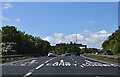
Junction for Mold from A55
Westbound junction with A494
Image: © John Firth
Taken: 4 May 2019
0.08 miles
2
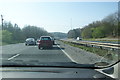
Standing traffic on the A55
The queue continues for about another 3 miles, due to some minor roadworks.
Image: © Bill Boaden
Taken: 24 Mar 2012
0.10 miles
3
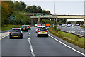
A494/A55 Junction near Ewloe
The A494 at the start of the North Wales Expressway (A55).
Image: © David Dixon
Taken: 24 Sep 2017
0.18 miles
5
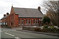
The Presbyterian Church at Ewloe Green
Beside the B5127
Image: © David Long
Taken: 6 Mar 2006
0.20 miles