IMAGES TAKEN NEAR TO
Weighbridge Road, DEESIDE, CH5 2UL
Introduction
This page details the photographs taken nearby to Weighbridge Road, CH5 2UL by members of the Geograph project.
The Geograph project started in 2005 with the aim of publishing, organising and preserving representative images for every square kilometre of Great Britain, Ireland and the Isle of Man.

There are currently over 7.5m images from over14,400 individuals and you can help contribute to the project by visiting https://www.geograph.org.uk
Image Map
Images are licensed for reuse under creativecommons.org/licenses/by-sa/2.0
Notes
- Clicking on the map will re-center to the selected point.
- The higher the marker number, the further away the image location is from the centre of the postcode.
Image Listing (4 Images Found)
Images are licensed for reuse under creativecommons.org/licenses/by-sa/2.0
Image
Details
Distance
1
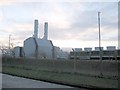
Deeside Power Station
A view looking southwest from the works access road to the Deeside 500MW combined cycle gas turbine (CCGT) power station operated by International Power.
Image: © Phil Williams
Taken: 31 Dec 2005
0.10 miles
2
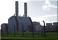
Power Base
Power Station on the Deeside Industrial Park.
Image: © J Scott
Taken: 27 Oct 2010
0.15 miles