IMAGES TAKEN NEAR TO
Glenesk Court, DEESIDE, CH5 2ST
Introduction
This page details the photographs taken nearby to Glenesk Court, CH5 2ST by members of the Geograph project.
The Geograph project started in 2005 with the aim of publishing, organising and preserving representative images for every square kilometre of Great Britain, Ireland and the Isle of Man.

There are currently over 7.5m images from over14,400 individuals and you can help contribute to the project by visiting https://www.geograph.org.uk
Image Map
Images are licensed for reuse under creativecommons.org/licenses/by-sa/2.0
Notes
- Clicking on the map will re-center to the selected point.
- The higher the marker number, the further away the image location is from the centre of the postcode.
Image Listing (16 Images Found)
Images are licensed for reuse under creativecommons.org/licenses/by-sa/2.0
Image
Details
Distance
1
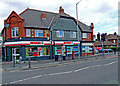
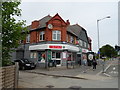
City shops
Post office and shops serving Garden City.
Image: © Dennis Turner
Taken: 29 Apr 2009
0.05 miles

3
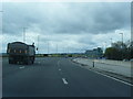
Suddenly the A550 gets very wide
Clear of the river Dee crossing, the road toward Manchester has been transformed from the simple dual carriageway of the early 1960s to a quasi-motorway with free-flow junctions throughout until the route flows seamlessly into the M56. Whether three or four lanes each way is merited is a moot point. It certainly creates an interesting chicane on the westbound carriageway, as can be seen.
Image: © Peter Whatley
Taken: 18 Jan 2011
0.06 miles
4
Post Office and shop on Welsh Road, Garden City
Image: © JThomas
Taken: 25 May 2019
0.09 miles
5
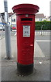
George V postbox on Welsh Road, Garden City
Postbox No. CH5 183.
Image: © JThomas
Taken: 25 May 2019
0.09 miles
6
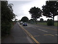
The road towards the "Blue Bridge"
What used to be the main road, now a suburban backwater. Image]
Image: © John Haynes
Taken: 18 Jun 2012
0.11 miles
7
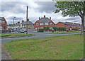
Garden City
Houses built by the nearby steelworks owners to house their workers.
Image: © Dennis Turner
Taken: 29 Apr 2009
0.13 miles
8
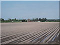
Ferrybank Farm
A farm on the silt lands that were created from salt marsh after the river was canalised in the 1730's. Silt soil is easily cultivated but production is drainage limited, this area has a pumped drainage system but the reason for the water sitting between the drills is the high rainfall in the last few weeks.
Image: © John Haynes
Taken: 2 May 2012
0.13 miles