IMAGES TAKEN NEAR TO
Station Road, DEESIDE, CH5 2PZ
Introduction
This page details the photographs taken nearby to Station Road, CH5 2PZ by members of the Geograph project.
The Geograph project started in 2005 with the aim of publishing, organising and preserving representative images for every square kilometre of Great Britain, Ireland and the Isle of Man.

There are currently over 7.5m images from over14,400 individuals and you can help contribute to the project by visiting https://www.geograph.org.uk
Image Map
Images are licensed for reuse under creativecommons.org/licenses/by-sa/2.0
Notes
- Clicking on the map will re-center to the selected point.
- The higher the marker number, the further away the image location is from the centre of the postcode.
Image Listing (9 Images Found)
Images are licensed for reuse under creativecommons.org/licenses/by-sa/2.0
Image
Details
Distance
1
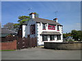
The Bridge Inn, Sandycroft
The Bridge Inn on the B5129 (Chester Road) at Sandycroft.
Image: © Jeff Buck
Taken: 4 May 2016
0.07 miles
2
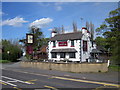
The Bridge Inn, Sandycroft
The Bridge Inn seen across the B5129 (Chester Road) at Sandycroft.
Image: © Jeff Buck
Taken: 4 May 2016
0.08 miles
3
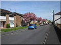
Phoenix Street, Sandycroft
Looking east along Phoenix Street from the junction with Wood Street.
Image: © Jeff Buck
Taken: 4 May 2016
0.13 miles
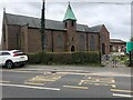
4
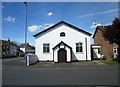
Sandycroft Methodist Chapel
Sandycroft Methodist Chapel in Phoenix Street, Sandycroft. The chapel was built in 1864 before which meetings were held in the open air.
Image: © Jeff Buck
Taken: 4 May 2016
0.16 miles
6
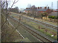
There used to be a station here.
Taken from the road bridge.
Image: © Stephen Charles
Taken: 18 Jan 2006
0.21 miles
8
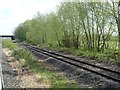
View from a Chester-Holyhead train - site of Sandycroft station
Opened in 1884 by the London & North Western Railway, this station closed in 1961.
For more information, see http://www.disused-stations.org.uk/s/sandycroft/index.shtml
Image: © Nigel Thompson
Taken: 2 May 2018
0.23 miles
9
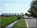
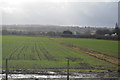
Broughton Brook and the B5129
Looking along Broughton Brook and the B5129 (Chester Road) towards the Airbus (Broughton) Factory.
Image: © Jeff Buck
Taken: 4 May 2016
0.24 miles