IMAGES TAKEN NEAR TO
Fourth Avenue, DEESIDE, CH5 2NR
Introduction
This page details the photographs taken nearby to Fourth Avenue, CH5 2NR by members of the Geograph project.
The Geograph project started in 2005 with the aim of publishing, organising and preserving representative images for every square kilometre of Great Britain, Ireland and the Isle of Man.

There are currently over 7.5m images from over14,400 individuals and you can help contribute to the project by visiting https://www.geograph.org.uk
Image Map
Images are licensed for reuse under creativecommons.org/licenses/by-sa/2.0
Notes
- Clicking on the map will re-center to the selected point.
- The higher the marker number, the further away the image location is from the centre of the postcode.
Image Listing (3 Images Found)
Images are licensed for reuse under creativecommons.org/licenses/by-sa/2.0
Image
Details
Distance
1
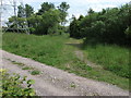
Looking into the wild area
The strip of trees, ponds and electrical transmission wires is a well established fishing area but there appears to be no access from this side, this view was taken through the boundary fence.
Image: © John Haynes
Taken: 18 Jun 2012
0.18 miles
2
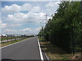
The long straight road
The access road continues around the edge of the industrial park but it looks as if a change is ahead. Walking through an industrial estate is a bit of a departure for me but I am impressed by the bird life in the trees, and overhead I have seen a sparrow hawk and a kestrel.
Image: © John Haynes
Taken: 18 Jun 2012
0.20 miles
3
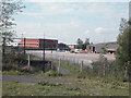
Industrial Estate Deeside
Part of the huge Industrial Park in Deeside based on the site of the former Shotton steelworks.
Image: © Dennis Turner
Taken: 11 Aug 2005
0.21 miles