IMAGES TAKEN NEAR TO
Parkway, DEESIDE, CH5 2NN
Introduction
This page details the photographs taken nearby to Parkway, CH5 2NN by members of the Geograph project.
The Geograph project started in 2005 with the aim of publishing, organising and preserving representative images for every square kilometre of Great Britain, Ireland and the Isle of Man.

There are currently over 7.5m images from over14,400 individuals and you can help contribute to the project by visiting https://www.geograph.org.uk
Image Map
Images are licensed for reuse under creativecommons.org/licenses/by-sa/2.0
Notes
- Clicking on the map will re-center to the selected point.
- The higher the marker number, the further away the image location is from the centre of the postcode.
Image Listing (7 Images Found)
Images are licensed for reuse under creativecommons.org/licenses/by-sa/2.0
Image
Details
Distance
1
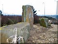
Standing Stones
Man-made Henge on a roundabout at the intersection of Zone (parth) 2 with the A548 on the Deeside Industrial Area.
Image: © Roger May
Taken: 4 Feb 2006
0.08 miles
2
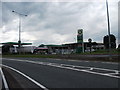
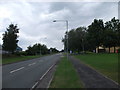
Service area on the edge of industrial estate
Services squeezed between the A548 and the industrial estate.
Image: © John Haynes
Taken: 18 Jun 2012
0.09 miles
3
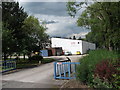
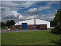
Small industrial unit
Typical of many of the medium size units on Deeside Industrial Estate.
Image: © John Haynes
Taken: 18 Jun 2012
0.09 miles
4
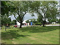
Green working environment
We have come a long way outside the factories in recent times. The large stones are to prevent unauthorised access to the grass. Image]
Image: © John Haynes
Taken: 18 Jun 2012
0.17 miles
5
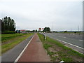
Dual use path beside the A548
Looking north west.
Image: © JThomas
Taken: 25 May 2019
0.17 miles
6
Polished up and ready to let
Vacant unit on Deeside Industrial Estate in 2012.
Image: © John Haynes
Taken: 18 Jun 2012
0.20 miles
7
The face of modern industry
This industrial estate is beginning to mature nicely with the grass and trees growing well.
Image: © John Haynes
Taken: 18 Jun 2012
0.24 miles