IMAGES TAKEN NEAR TO
Green Lane Estate, Green Lane, DEESIDE, CH5 2NG
Introduction
This page details the photographs taken nearby to Green Lane Estate, Green Lane, CH5 2NG by members of the Geograph project.
The Geograph project started in 2005 with the aim of publishing, organising and preserving representative images for every square kilometre of Great Britain, Ireland and the Isle of Man.

There are currently over 7.5m images from over14,400 individuals and you can help contribute to the project by visiting https://www.geograph.org.uk
Image Map
Images are licensed for reuse under creativecommons.org/licenses/by-sa/2.0
Notes
- Clicking on the map will re-center to the selected point.
- The higher the marker number, the further away the image location is from the centre of the postcode.
Image Listing (8 Images Found)
Images are licensed for reuse under creativecommons.org/licenses/by-sa/2.0
Image
Details
Distance
1
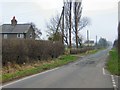
Green Lane to Sealand
View south-east past Marsh Farm, down the Green Lane which leads into Sealand.
Image: © Roger May
Taken: 4 Feb 2006
0.09 miles

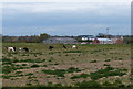
3
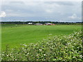
Farmland towards Bridge Farm
View from National Cycle Route 5.
Image: © JThomas
Taken: 15 Jun 2019
0.18 miles
4
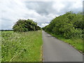
National Cycle Route 5 towards Chester
On a disused railway track bed.
Image: © JThomas
Taken: 15 Jun 2019
0.21 miles
5
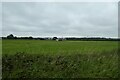
Towards Bridge Farm
Looking towards the farm from the Chester Rail Path.
Image: © DS Pugh
Taken: 8 Aug 2020
0.21 miles
6
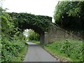
Bridge over cycle route (NCN5) close to Old Marsh Farm
Image: © David Smith
Taken: 6 May 2023
0.23 miles
8
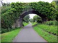
Bridge over the Millennium Greenway, Sealand
Image: © Jeff Buck
Taken: 1 Aug 2012
0.24 miles