IMAGES TAKEN NEAR TO
Mill View Road, DEESIDE, CH5 1HS
Introduction
This page details the photographs taken nearby to Mill View Road, CH5 1HS by members of the Geograph project.
The Geograph project started in 2005 with the aim of publishing, organising and preserving representative images for every square kilometre of Great Britain, Ireland and the Isle of Man.

There are currently over 7.5m images from over14,400 individuals and you can help contribute to the project by visiting https://www.geograph.org.uk
Image Map
Images are licensed for reuse under creativecommons.org/licenses/by-sa/2.0
Notes
- Clicking on the map will re-center to the selected point.
- The higher the marker number, the further away the image location is from the centre of the postcode.
Image Listing (11 Images Found)
Images are licensed for reuse under creativecommons.org/licenses/by-sa/2.0
Image
Details
Distance
1
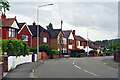
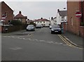
Wepre Park, Connah's Quay
The High Street in Connah's Quay looks distinctly down-at-heel in places but here to the south of it there is an air of quiet suburban prosperity. This is Wepre Park, the road, which confusingly leads to Wepre Park, the park. Wepre is a much older name than Connah's Quay and is still used as a name for this part of the town.
Image: © Stephen McKay
Taken: 11 Jul 2023
0.17 miles
2
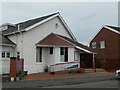
Christ Church, Shotton
On Victoria Road.
Image: © Eirian Evans
Taken: 11 Feb 2011
0.17 miles
3
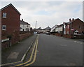
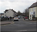
Victoria Road, Shotton
Towards the Beaconsfield Road junction on the left. The Rowden Street junction https://www.geograph.org.uk/photo/5689948 is on the right.
Image: © Jaggery
Taken: 22 Feb 2018
0.19 miles
4
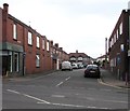
Rowden Street, Shotton
One-way street viewed across Chester Road West from the corner of Bridge Street.
Image: © Jaggery
Taken: 22 Feb 2018
0.22 miles
5
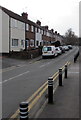
No Entry signs, Rowden Street, Shotton
Facing Victoria Road.
Image: © Jaggery
Taken: 22 Feb 2018
0.22 miles
6
Brook Road, Shotton
On a bank of Wepre Brook which here marks the boundary between Shotton and Connah's Quay.
Image: © Jaggery
Taken: 22 Feb 2018
0.22 miles
7
Brook Road, Shotton
On a bank of Wepre Brook which here marks the boundary between Shotton and Connah's Quay.
Viewed from the corner of the B5129 Chester Road West.
Image: © Jaggery
Taken: 22 Feb 2018
0.22 miles
8
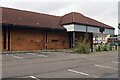
Former Co-op, Connah's Quay
This derelict building does nothing for the local townscape and unsurprisingly there have been reports of anti-social behaviour in the area. It was built as a Somerfield supermarket but after that company was taken over by the Co-op it was refurbished and rebranded, reopening in July 2010 when it was described as a 'very important facility for the community'. Be that as it may, it closed down just two years later with the loss of over 30 jobs. Quite why the Co-op couldn't make a success of this well-located supermarket with plenty of parking may never be known but the organisation has long had a policy of concentrating on smaller convenience stores. According to local newspaper reports Lidl has expressed an interest in the site that would involve demolishing the old building and replacing it with a state-of-the-art modern store. In any case nothing has happened yet.
Image: © Stephen McKay
Taken: 11 Jul 2023
0.23 miles
9

Connah's Quay - buddleja and graffiti
A sense of urban decay surrounds this former supermarket in Connah's Quay with graffiti scrawled on the walls and buddleja sprouting freely. The story of the building is told here: Image
Image: © Stephen McKay
Taken: 11 Jul 2023
0.23 miles
10
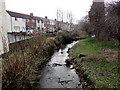
Rubbish dumped in Wepre Brook, Shotton
Looking downstream from Wepre Bridge. Wepre Brook is a tributary of the River Dee.
Brook Road is on the left.
Image: © Jaggery
Taken: 22 Feb 2018
0.24 miles