IMAGES TAKEN NEAR TO
Church Road, CHESTER, CH4 9HZ
Introduction
This page details the photographs taken nearby to Church Road, CH4 9HZ by members of the Geograph project.
The Geograph project started in 2005 with the aim of publishing, organising and preserving representative images for every square kilometre of Great Britain, Ireland and the Isle of Man.

There are currently over 7.5m images from over14,400 individuals and you can help contribute to the project by visiting https://www.geograph.org.uk
Image Map
Images are licensed for reuse under creativecommons.org/licenses/by-sa/2.0
Notes
- Clicking on the map will re-center to the selected point.
- The higher the marker number, the further away the image location is from the centre of the postcode.
Image Listing (60 Images Found)
Images are licensed for reuse under creativecommons.org/licenses/by-sa/2.0
Image
Details
Distance
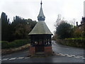
1
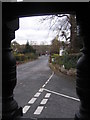
Church Road from the shelter
Looking along Church Road from within the shelter at the junction of Hill Road, Church Road, and Paddock Road.
Image: © John S Turner
Taken: 18 Nov 2008
0.02 miles
2
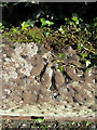
Pivot bench mark in Church Road, Eccleston
This bench mark is on top of the sandstone garden wall in front of Church View, Church Road, Eccleston. In 2012 it was disguised by a layer of moss, which has re-established itself by 2015. See also Image
Image: © John S Turner
Taken: 16 May 2012
0.02 miles
3
Church Road, Eccleston
Looking along Church Road from in front of Church View. There is an Ordnance Survey pivot bench mark on the rounded sandstone wall on the right, close to the drive entrance to Church View - see Image
Image: © John S Turner
Taken: 16 May 2012
0.03 miles
4
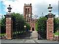
Gates, Eccleston
Good early C18th gates by the Davies Bros at the approach to the church (Image]). The gates and rusticated piers were brought here from Emral Hall (in Flintshire) when it was demolished. Grade II listed.
Image: © Stephen Richards
Taken: 19 Aug 2014
0.04 miles
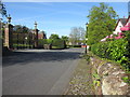
6
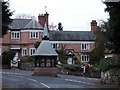
Junction of Hill Road, Paddock Road and Church Road, Eccleston
View northwards from Paddock Road, featuring the village Pump House. http://ecclestonvillage.co.uk/1.html
Image: © Ian Paterson
Taken: 12 Nov 2008
0.04 miles
7
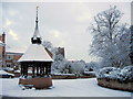
Paddock Road/Church Road junction and the shelter in the snow
Looking past the snow covered shelter at the junction of Paddock Road and Church Road, with the church of St Mary the Virgin in the background.
Image: © John S Turner
Taken: 22 Dec 2010
0.04 miles
8
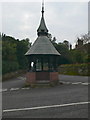
The Pump House, Eccleston
On the junction of Church Road and Paddock Road.
Image: © Eirian Evans
Taken: 17 Sep 2008
0.04 miles
9
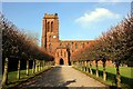
St Mary's Church, Eccleston
The original medieval church was entirely rebuilt in 1809 by William Porden for Earl Grosvenor.
St Mary's Wikipedia http://en.wikipedia.org/wiki/St_Mary%27s_Church,_Eccleston
Eccleston Wikipedia http://en.wikipedia.org/wiki/Eccleston,_Cheshire
Image: © Jeff Buck
Taken: 18 Feb 2013
0.04 miles
10
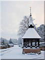
Church Road and the shelter in the snow
Looking past the shelter towards Church Road following a very Christmassy fall of snow.
Image: © John S Turner
Taken: 22 Dec 2010
0.04 miles