IMAGES TAKEN NEAR TO
Eccleston Road, CHESTER, CH4 9DY
Introduction
This page details the photographs taken nearby to Eccleston Road, CH4 9DY by members of the Geograph project.
The Geograph project started in 2005 with the aim of publishing, organising and preserving representative images for every square kilometre of Great Britain, Ireland and the Isle of Man.

There are currently over 7.5m images from over14,400 individuals and you can help contribute to the project by visiting https://www.geograph.org.uk
Image Map
Images are licensed for reuse under creativecommons.org/licenses/by-sa/2.0
Notes
- Clicking on the map will re-center to the selected point.
- The higher the marker number, the further away the image location is from the centre of the postcode.
Image Listing (21 Images Found)
Images are licensed for reuse under creativecommons.org/licenses/by-sa/2.0
Image
Details
Distance
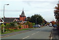
1
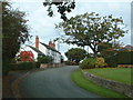
Bennets Lane, Higher Kinnerton
Approaching village from east south-east.
Image: © Michael Campbell
Taken: 18 Oct 2007
0.05 miles
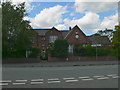
2
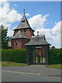
All Saints Church, Higher Kinnerton
Higher Kinnerton is in the south-east of Flintshire, bordering Chester and Wrexham. All Saints Church is a red-brick building, built in 1893, is in the parish of Dodleston, which is in England.
Image: © Eirian Evans
Taken: 4 Jun 2008
0.12 miles
3
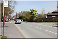
Main Road, Higher Kinnerton
On the right is Higher Kinnerton village hall on the junction with Bennetts Lane.
Image: © Jeff Buck
Taken: 2 May 2013
0.12 miles
4
Old School and Schoolhouse
On Main Road, Higher Kinnerton
Image: © Eirian Evans
Taken: 15 Jan 2019
0.12 miles
5
Main Road, Higher Kinnerton
Looking North towards village centre. All Saints Church Prominent mid-picture.
Image: © Michael Campbell
Taken: 18 Oct 2007
0.13 miles
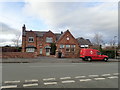
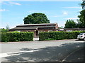
6
The Old School, Higher Kinnerton
Built in 1872, the school has now been converted into offices for a graphic design company.
Image: © Eirian Evans
Taken: 4 Jun 2008
0.13 miles
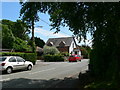
7
Higher Kinnerton Village Hall
On the corner of Main Road and Bennetts Lane.
Image: © Eirian Evans
Taken: 4 Jun 2008
0.13 miles
8
Bennetts Lane, Higher Kinnerton
The building in the centre is Higher Kinnerton's Post Office.
Image: © Eirian Evans
Taken: 4 Jun 2008
0.13 miles
9
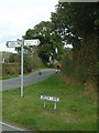
Higher Kinnerton
Green Lane, Sandy Lane, Bennets Lane junction.
Image: © Michael Campbell
Taken: 18 Oct 2007
0.13 miles
10
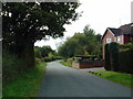
Sandy Lane, Higher Kinnerton
Looking southeast along Sandy Lane.
Image: © Michael Campbell
Taken: 18 Oct 2007
0.14 miles