IMAGES TAKEN NEAR TO
Wrexham Road, CHESTER, CH4 9DG
Introduction
This page details the photographs taken nearby to Wrexham Road, CH4 9DG by members of the Geograph project.
The Geograph project started in 2005 with the aim of publishing, organising and preserving representative images for every square kilometre of Great Britain, Ireland and the Isle of Man.

There are currently over 7.5m images from over14,400 individuals and you can help contribute to the project by visiting https://www.geograph.org.uk
Image Map
Images are licensed for reuse under creativecommons.org/licenses/by-sa/2.0
Notes
- Clicking on the map will re-center to the selected point.
- The higher the marker number, the further away the image location is from the centre of the postcode.
Image Listing (5 Images Found)
Images are licensed for reuse under creativecommons.org/licenses/by-sa/2.0
Image
Details
Distance
1
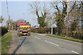
The A5445 (Wrexham Road) near Pulford
The A5445 heading north away from Pulford taken from near the entrance to The Manor. The entrance to Lyndale Farm is across the road beyond the street light.
Image: © Jeff Buck
Taken: 18 Feb 2013
0.04 miles
3
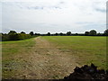
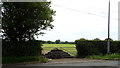
Cut silage field near The Elms
Off Wrexham Road (B5445).
Image: © JThomas
Taken: 25 May 2019
0.16 miles
4
Field entrance off Wrexham Road (B5445)
Blocked by a pile of muck.
Image: © JThomas
Taken: 25 May 2019
0.17 miles