
IMAGES TAKEN NEAR TO
Sunflower Close, WIRRAL, CH49 9EH
Introduction
This page details the photographs taken nearby to Sunflower Close, CH49 9EH by members of the Geograph project.
The Geograph project started in 2005 with the aim of publishing, organising and preserving representative images for every square kilometre of Great Britain, Ireland and the Isle of Man.

There are currently over 7.5m images from over14,400 individuals and you can help contribute to the project by visiting https://www.geograph.org.uk
Image Map
Images are licensed for reuse under creativecommons.org/licenses/by-sa/2.0
Notes
- Clicking on the map will re-center to the selected point.
- The higher the marker number, the further away the image location is from the centre of the postcode.
Image Listing (28 Images Found)
Images are licensed for reuse under creativecommons.org/licenses/by-sa/2.0
Image
Details
Distance
1
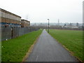
National Cycle Network near Woodchurch
The tarmac path was built in the early 2000's as part of Sustran's National Route 56 between Liverpool and Chester. Being where it is, the path is littered with graffiti markings in places and it is not uncommon for there to be broken glass on the path every morning. The building on the left is the former St. Benedict's Comprehensive School, which itself is now looking derelict.
Image: © David Quinn
Taken: 22 Dec 2007
0.05 miles

3

Electricity pylon
Along a footpath between the railway line and the M53. Not the nicest place for a pleasant walk!
Image: © Fractal Angel
Taken: 16 Aug 2007
0.16 miles
5

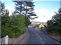
Library, Upton
Nice Deco effort by Richard Furniss, 1936. In plan it resembles a space invader. Grade II listed.
Run by Wirral Council.
Image: © Stephen Richards
Taken: 22 Aug 2014
0.17 miles
6
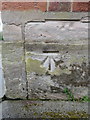
Bench mark on Upton Library, Wirral
This Ordnance Survey bench mark is on the north west corner of Upton Library, Ford Road. See also Image
Image: © John S Turner
Taken: 25 May 2018
0.18 miles
7
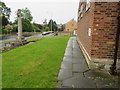
Upton Library and War Memorial in Ford Road
Looking along the north face of Upton Library with the War Memorial on the left. There is an Ordnance Survey bench mark on the near corner of the library - Image
Image: © John S Turner
Taken: 25 May 2018
0.18 miles
9
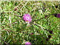
Thistles
On the side of the Fender Way footpath. I was really lucky to capture a bee landing on the thistle.
Image: © David Quinn
Taken: 24 Jul 2007
0.19 miles
10
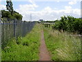
Fender Way footpath
A footpath that links Noctorum with Prenton located in between a motorway and Woodchurch estate on the west side and a railway line and Nocturum estate on the east side.
Image: © David Quinn
Taken: 24 Jul 2007
0.20 miles