IMAGES TAKEN NEAR TO
Surrey Avenue, WIRRAL, CH49 6NL
Introduction
This page details the photographs taken nearby to Surrey Avenue, CH49 6NL by members of the Geograph project.
The Geograph project started in 2005 with the aim of publishing, organising and preserving representative images for every square kilometre of Great Britain, Ireland and the Isle of Man.

There are currently over 7.5m images from over14,400 individuals and you can help contribute to the project by visiting https://www.geograph.org.uk
Image Map (Loading...)


Getting Data...Please wait
Leaflet Map data © OpenStreetMap
Images are licensed for reuse under creativecommons.org/licenses/by-sa/2.0
Notes
- Clicking on the map will re-center to the selected point.
- The higher the marker number, the further away the image location is from the centre of the postcode.
Image Listing (10 Images Found)
Images are licensed for reuse under creativecommons.org/licenses/by-sa/2.0
Image
Details
Distance
2
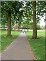
Overchurch Park, Upton
A small urban park located in Overchurch, a mainly residential area of Upton.
Image: © David Quinn
Taken: 26 May 2008
0.14 miles
5
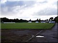
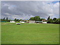
Upton Cricket Club, Old Greasby Road
Upton Bypass is to the left of the picture.
Image: © El Pollock
Taken: 21 Jul 2009
0.20 miles
6
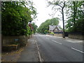
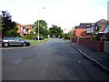
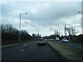
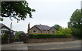
Moreton Road, Upton
Looking north west on the A551.
Image: © JThomas
Taken: 25 May 2019
0.20 miles
8
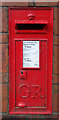
George V postbox on Moreton Road, Upton
Postbox No. CH49 442.
Image: © JThomas
Taken: 25 May 2019
0.22 miles
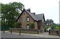
10
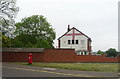
Patriot's house on Doncaster Drive, Upton
Showing position of Postbox No. CH49 315.
Image: © JThomas
Taken: 25 May 2019
0.25 miles