IMAGES TAKEN NEAR TO
Upton Park Drive, WIRRAL, CH49 6JW
Introduction
This page details the photographs taken nearby to Upton Park Drive, CH49 6JW by members of the Geograph project.
The Geograph project started in 2005 with the aim of publishing, organising and preserving representative images for every square kilometre of Great Britain, Ireland and the Isle of Man.

There are currently over 7.5m images from over14,400 individuals and you can help contribute to the project by visiting https://www.geograph.org.uk
Image Map (Loading...)


Getting Data...Please wait
Leaflet Map data © OpenStreetMap
Images are licensed for reuse under creativecommons.org/licenses/by-sa/2.0
Notes
- Clicking on the map will re-center to the selected point.
- The higher the marker number, the further away the image location is from the centre of the postcode.
Image Listing (5 Images Found)
Images are licensed for reuse under creativecommons.org/licenses/by-sa/2.0
Image
Details
Distance
2
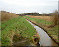
River Fender
The Fender is a small river between Prenton and its confluence with The Birket near Leasowe. The river has been artificially straightened here, possibly to make building either the nearby housing estate or the motorway easier.
Image: © David Quinn
Taken: 30 Dec 2007
0.19 miles
4
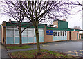
Ofsted Outstanding
Hayfield school, Manor Drive, Upton
Image: © J Scott
Taken: 14 Nov 2010
0.21 miles
5
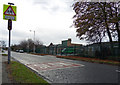
Slow School
Hayfield School, Manor Drive, Upton.
Image: © J Scott
Taken: 14 Nov 2010
0.21 miles