IMAGES TAKEN NEAR TO
The Warren, WIRRAL, CH49 6JH
Introduction
This page details the photographs taken nearby to The Warren, CH49 6JH by members of the Geograph project.
The Geograph project started in 2005 with the aim of publishing, organising and preserving representative images for every square kilometre of Great Britain, Ireland and the Isle of Man.

There are currently over 7.5m images from over14,400 individuals and you can help contribute to the project by visiting https://www.geograph.org.uk
Image Map (Loading...)


Getting Data...Please wait
Leaflet Map data © OpenStreetMap
Images are licensed for reuse under creativecommons.org/licenses/by-sa/2.0
Notes
- Clicking on the map will re-center to the selected point.
- The higher the marker number, the further away the image location is from the centre of the postcode.
Image Listing (30 Images Found)
Images are licensed for reuse under creativecommons.org/licenses/by-sa/2.0
Image
Details
Distance
3
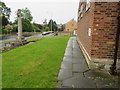
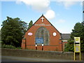
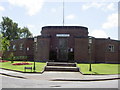
Upton Library and War Memorial in Ford Road
Looking along the north face of Upton Library with the War Memorial on the left. There is an Ordnance Survey bench mark on the near corner of the library - Image
Image: © John S Turner
Taken: 25 May 2018
0.13 miles
4
Library, Upton
Nice Deco effort by Richard Furniss, 1936. In plan it resembles a space invader. Grade II listed.
Run by Wirral Council.
Image: © Stephen Richards
Taken: 22 Aug 2014
0.13 miles
6
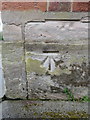
Bench mark on Upton Library, Wirral
This Ordnance Survey bench mark is on the north west corner of Upton Library, Ford Road. See also Image
Image: © John S Turner
Taken: 25 May 2018
0.13 miles
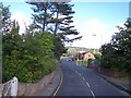
7
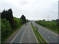
M53 Motorway, Birkenhead
Looking north from the bridge on the A5027.
Image: © JThomas
Taken: 25 May 2019
0.15 miles
9
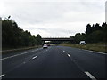
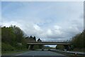
M53 southbound approaching Upton Road overbridge
Image: © Colin Pyle
Taken: 2 Oct 2012
0.16 miles
10
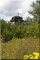
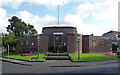
Strange structure near Upton station
This ruined tower lurking behind an electricity substation looks as if it might once have been a support for a bridge, perhaps before the nearby M53 motorway was built.
Update June 2020: Geograph Moderator, Alan Murray-Rust writes "Not a bridge support. This is the remaining base of the chimney of what was originally a steam-powered Ford Pumping Station, part of Birkenhead Corporation Water Works. Old maps suggest that steam operation had been replaced by the 1930s, almost certainly by electric pumps housed in the building that remains. The decorative base of the chimney would have been much more trouble to demolish than the rest of the chimney, so was left in place. The electricity substation is on the site of the pump house."
Image: © Fractal Angel
Taken: 16 Aug 2007
0.20 miles