IMAGES TAKEN NEAR TO
Concordia Avenue, WIRRAL, CH49 6JD
Introduction
This page details the photographs taken nearby to Concordia Avenue, CH49 6JD by members of the Geograph project.
The Geograph project started in 2005 with the aim of publishing, organising and preserving representative images for every square kilometre of Great Britain, Ireland and the Isle of Man.

There are currently over 7.5m images from over14,400 individuals and you can help contribute to the project by visiting https://www.geograph.org.uk
Image Map (Loading...)


Getting Data...Please wait
Leaflet Map data © OpenStreetMap
Images are licensed for reuse under creativecommons.org/licenses/by-sa/2.0
Notes
- Clicking on the map will re-center to the selected point.
- The higher the marker number, the further away the image location is from the centre of the postcode.
Image Listing (8 Images Found)
Images are licensed for reuse under creativecommons.org/licenses/by-sa/2.0
Image
Details
Distance
4
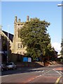
St. Mary's Church, Upton
Built in 1868 by William Inman. St. Mary's Church is on Ford Road, at the junction with Church Road.
Image: © El Pollock
Taken: 20 Jul 2009
0.22 miles
5
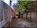
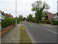
The Spinney
The Spinney path from the highest part near West Drive
Image: © Mihacel
Taken: 10 Jan 2022
0.23 miles
7

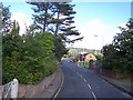
M53 Motorway
View looking along the M53 motorway.
Image: © Peter McDermott
Taken: 25 May 2017
0.25 miles
8
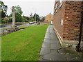
Upton Library and War Memorial in Ford Road
Looking along the north face of Upton Library with the War Memorial on the left. There is an Ordnance Survey bench mark on the near corner of the library - Image
Image: © John S Turner
Taken: 25 May 2018
0.25 miles