IMAGES TAKEN NEAR TO
Litcham Close, WIRRAL, CH49 4GN
Introduction
This page details the photographs taken nearby to Litcham Close, CH49 4GN by members of the Geograph project.
The Geograph project started in 2005 with the aim of publishing, organising and preserving representative images for every square kilometre of Great Britain, Ireland and the Isle of Man.

There are currently over 7.5m images from over14,400 individuals and you can help contribute to the project by visiting https://www.geograph.org.uk
Image Map
Images are licensed for reuse under creativecommons.org/licenses/by-sa/2.0
Notes
- Clicking on the map will re-center to the selected point.
- The higher the marker number, the further away the image location is from the centre of the postcode.
Image Listing (7 Images Found)
Images are licensed for reuse under creativecommons.org/licenses/by-sa/2.0
Image
Details
Distance
1
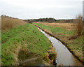
River Fender
The Fender is a small river between Prenton and its confluence with The Birket near Leasowe. The river has been artificially straightened here, possibly to make building either the nearby housing estate or the motorway easier.
Image: © David Quinn
Taken: 30 Dec 2007
0.14 miles
2
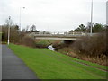
Road Bridge over the Fender.
The bridge carries part of junction 2 of the motorway over the River Fender. The track has been made by a local farmer to transport cows between a short stretch of field in this square, and the main part of his farm 1 square to the north.
Image: © David Quinn
Taken: 30 Dec 2007
0.14 miles
3
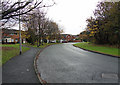
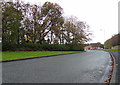
Tree Lined
Tree refuse alongside Norwich Drive, Upton.
Image: © J Scott
Taken: 14 Nov 2010
0.17 miles
6
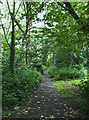
A footpath through woodland off Norwich Drive
Image: © Ian Greig
Taken: 16 Jun 2017
0.19 miles
7
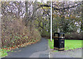
Litter Here
Footpath leading from Northwich Drive to Hunstanton Drive, Upton.
Image: © J Scott
Taken: 14 Nov 2010
0.21 miles