IMAGES TAKEN NEAR TO
Shepherd Close, WIRRAL, CH49 2RB
Introduction
This page details the photographs taken nearby to Shepherd Close, CH49 2RB by members of the Geograph project.
The Geograph project started in 2005 with the aim of publishing, organising and preserving representative images for every square kilometre of Great Britain, Ireland and the Isle of Man.

There are currently over 7.5m images from over14,400 individuals and you can help contribute to the project by visiting https://www.geograph.org.uk
Image Map (Loading...)


Getting Data...Please wait
Leaflet Map data © OpenStreetMap
Images are licensed for reuse under creativecommons.org/licenses/by-sa/2.0
Notes
- Clicking on the map will re-center to the selected point.
- The higher the marker number, the further away the image location is from the centre of the postcode.
Image Listing (5 Images Found)
Images are licensed for reuse under creativecommons.org/licenses/by-sa/2.0
Image
Details
Distance
1
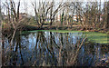
Pond Reflection
Reflection of houses in Stapleton Avenue in drainage pond.
Image: © J Scott
Taken: 13 Feb 2008
0.12 miles
2
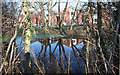
Across The Pond
View across drainage pond to Hambledon Drive.
Image: © J Scott
Taken: 13 Feb 2008
0.12 miles
3
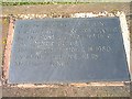
Inlaid Restoration Stone
Slate inlaid plaque detailing Greasby Village's original water source.
Image: © J Scott
Taken: 28 Jul 1999
0.23 miles
4
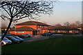
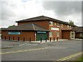
Health Centre
Greasby Health centre housing GPs and NHS Trust medical facilities. Chemist attached.
Image: © J Scott
Taken: 13 Feb 2008
0.25 miles