IMAGES TAKEN NEAR TO
Ford Road, WIRRAL, CH49 0TQ
Introduction
This page details the photographs taken nearby to Ford Road, CH49 0TQ by members of the Geograph project.
The Geograph project started in 2005 with the aim of publishing, organising and preserving representative images for every square kilometre of Great Britain, Ireland and the Isle of Man.

There are currently over 7.5m images from over14,400 individuals and you can help contribute to the project by visiting https://www.geograph.org.uk
Image Map (Loading...)


Getting Data...Please wait
Leaflet Map data © OpenStreetMap
Images are licensed for reuse under creativecommons.org/licenses/by-sa/2.0
Notes
- Clicking on the map will re-center to the selected point.
- The higher the marker number, the further away the image location is from the centre of the postcode.
Image Listing (28 Images Found)
Images are licensed for reuse under creativecommons.org/licenses/by-sa/2.0
Image
Details
Distance
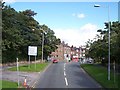
1

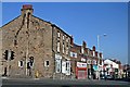
Shops, Ford Road, Upton Village
To the left, just beyond the first set of traffic lights, is the junction with Rake Lane. Looking in the direction of Greasby.
Image: © El Pollock
Taken: 12 Jun 2012
0.02 miles
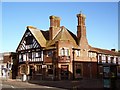
2
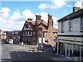
The Stonehouse, Ford Road, Upton Village
At the top of Ford Road, seen from across the junction with the A551. The building, originally a dairy, was constructed from local sandstone. One half is now a hairdressers premises. The other half of the building has been, at various times, a cafe, a milliners, and a florist.
Image: © El Pollock
Taken: 25 Mar 2012
0.03 miles
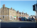
4
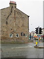
Moreton Road crossing, Upton, Wirral
Looking across Moreton Road towards the side wall of #148 Ford Road. There is an Ordnance Survey bench mark below the right-hand window of the large building, which is shared by a hairdressers and a café. Image
Image: © John S Turner
Taken: 25 May 2018
0.04 miles
5
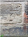
Bench mark in Moreton Road, Upton, Wirral
Although this Ordnance Survey bench mark is actually in Moreton Road, officially it is on the side wall of #148 Ford Road. See also Image
Image: © John S Turner
Taken: 25 May 2018
0.04 miles
6
Old Greasby Road crossroads at Upton
Image: © Raymond Knapman
Taken: 30 Aug 2012
0.04 miles
7
Eagle & Crown Public House, Upton
The Eagle & Crown is on Ford Road, Upton, at the junction to Rake Lane.
Image: © El Pollock
Taken: 20 Jul 2009
0.05 miles
8
Upton Village
Ford Road at its junction with Arrowe Park Road (A551), taken from Old Greasby Road
Image: © Sue Adair
Taken: 13 Nov 2005
0.05 miles
9
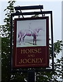
Sign for the Horse and Jockey, Upton
See Image] for context.
Image: © JThomas
Taken: 25 May 2019
0.06 miles
