IMAGES TAKEN NEAR TO
Ford Road, WIRRAL, CH49 0TE
Introduction
This page details the photographs taken nearby to Ford Road, CH49 0TE by members of the Geograph project.
The Geograph project started in 2005 with the aim of publishing, organising and preserving representative images for every square kilometre of Great Britain, Ireland and the Isle of Man.

There are currently over 7.5m images from over14,400 individuals and you can help contribute to the project by visiting https://www.geograph.org.uk
Image Map
Images are licensed for reuse under creativecommons.org/licenses/by-sa/2.0
Notes
- Clicking on the map will re-center to the selected point.
- The higher the marker number, the further away the image location is from the centre of the postcode.
Image Listing (30 Images Found)
Images are licensed for reuse under creativecommons.org/licenses/by-sa/2.0
Image
Details
Distance
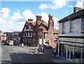
1
Ford Road, Upton
St. Mary's Church & Upton Village are just in view, up the road.
Image: © El Pollock
Taken: 1 Mar 2012
0.01 miles
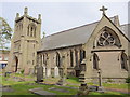
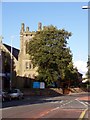
2
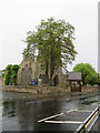
St Mary's church, Ford Road, Upton, Wirral
Looking towards St Mary's church across Ford Road, Upton on a very wet day. The church has an Ordnance Survey bench mark on the tower buttress immediately behind the large tree - Image
Image: © John S Turner
Taken: 25 May 2018
0.03 miles
3
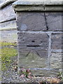
Bench mark on St Mary's church tower, Upton, Wirral
This Ordnance Survey bench mark is on the south west buttress of St Mary's church tower, Upton. See also Image
Image: © John S Turner
Taken: 25 May 2018
0.03 miles
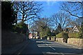
4
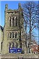
St. Mary's Church Bell Tower, Ford Road, Upton
Situated at the junction with Church Road. Designed by the Scottish architect John Cunningham &, in the main, paid for by the shipowner William Inman, the church was consecrated on the 28th April 1868. The clock was installed in 1912.
Image: © El Pollock
Taken: 25 Mar 2012
0.03 miles
5
Upton by Birkenhead, Merseyside, St Mary
Image: © Dave Kelly
Taken: 25 May 2018
0.03 miles
6
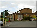
Upton Victory Hall
Upton Victory Hall is a local sports and community centre built in the 1920s to commemorate the fallen of WW1. This is the Salacre Lane building which houses the bowls, croquet, badminton, bridge, singing and other clubs. There is another building off Rake Lane which houses the tennis club.
Image: © David Quinn
Taken: 20 Jul 2008
0.04 miles

8
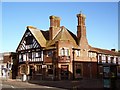
Eagle & Crown Public House, Upton
The Eagle & Crown is on Ford Road, Upton, at the junction to Rake Lane.
Image: © El Pollock
Taken: 20 Jul 2009
0.05 miles
9
St. Mary's Church, Upton
Built in 1868 by William Inman. St. Mary's Church is on Ford Road, at the junction with Church Road.
Image: © El Pollock
Taken: 20 Jul 2009
0.05 miles