IMAGES TAKEN NEAR TO
Park Avenue, CHESTER, CH4 8TR
Introduction
This page details the photographs taken nearby to Park Avenue, CH4 8TR by members of the Geograph project.
The Geograph project started in 2005 with the aim of publishing, organising and preserving representative images for every square kilometre of Great Britain, Ireland and the Isle of Man.

There are currently over 7.5m images from over14,400 individuals and you can help contribute to the project by visiting https://www.geograph.org.uk
Image Map
Images are licensed for reuse under creativecommons.org/licenses/by-sa/2.0
Notes
- Clicking on the map will re-center to the selected point.
- The higher the marker number, the further away the image location is from the centre of the postcode.
Image Listing (16 Images Found)
Images are licensed for reuse under creativecommons.org/licenses/by-sa/2.0
Image
Details
Distance
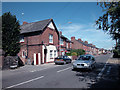
1
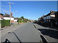
Park Avenue, Saltney
Looking north towards the junction with Irving's Crescent.
Wikipedia http://en.wikipedia.org/wiki/Saltney
Image: © Jeff Buck
Taken: 10 Oct 2013
0.06 miles
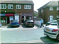
2
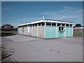
Saltney Public Library
A Flintshire County Council library
Image: © Dennis Turner
Taken: 10 Aug 2005
0.15 miles
3
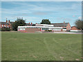
St Anthony's school
Catholic primary school in High Street Saltney.
Image: © Dennis Turner
Taken: 10 Aug 2005
0.15 miles
4
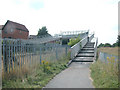
International Footbridge
Linking Wales and England. The footbridge, which crosses the Chester to Wrexham railway line, provides access from the Lache district of Chester with the Welsh border town of Saltney.
Image: © Dennis Turner
Taken: 18 Aug 2005
0.17 miles
5
High Street Saltney
Main road through Saltney from Hawarden to Chester
Image: © Dennis Turner
Taken: 10 Aug 2005
0.17 miles
8
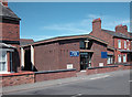
Methodist Church Saltney
Modern church building in High Street Saltney.
Image: © Dennis Turner
Taken: 10 Aug 2005
0.21 miles
9
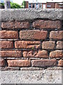
Weathered bench mark on Saltney High Street
This bench mark is on an old low wall in front of the more modern Saltney Social Club. The area was once terraced housing but that was all demolished around the 1960s. This wall is obviously associated with the old housing, but if the multi million pound Saltney Development plan ever goes ahead I would expect this wall to be swept away.
Image: © John S Turner
Taken: 20 Jul 2009
0.21 miles
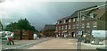
10
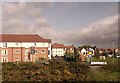
New house construction off Boundary Lane
The buildings to the left are apartments
Image: © John Firth
Taken: 10 May 2014
0.22 miles