IMAGES TAKEN NEAR TO
Riverside Lane, CHESTER, CH4 8RS
Introduction
This page details the photographs taken nearby to Riverside Lane, CH4 8RS by members of the Geograph project.
The Geograph project started in 2005 with the aim of publishing, organising and preserving representative images for every square kilometre of Great Britain, Ireland and the Isle of Man.

There are currently over 7.5m images from over14,400 individuals and you can help contribute to the project by visiting https://www.geograph.org.uk
Image Map
Images are licensed for reuse under creativecommons.org/licenses/by-sa/2.0
Notes
- Clicking on the map will re-center to the selected point.
- The higher the marker number, the further away the image location is from the centre of the postcode.
Image Listing (55 Images Found)
Images are licensed for reuse under creativecommons.org/licenses/by-sa/2.0
Image
Details
Distance
1
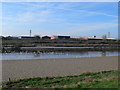
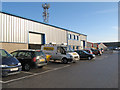
Looking across the Dee towards the Borders Industrial Park
Image: © Eirian Evans
Taken: 1 Mar 2012
0.04 miles
2

A shy Goldfinch
Not the best photo of a Goldfinch (Carduelis carduelis), but perhaps representative of what a snapshot photographer (like me) can get whilst out for a walk, and it does prove that they live near the River Dee in Saltney.
Image: © John S Turner
Taken: 19 Sep 2015
0.07 miles
3
Llwybr Arfordir Cymru
The Wales Coast Path heading towards Chester.
http://www.ccgc.gov.uk/enjoying-the-country/wales-coast-path.aspx?lang=cy-gb
http://www.ccw.gov.uk/enjoying-the-country/wales-coast-path.aspx?lang=en
Image: © John Haynes
Taken: 2 May 2012
0.07 miles
4
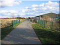
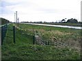
Dee Coastal Path, Saltney
Here the Dee Coastal Path crosses an unnamed brook and heads towards River Lane in Saltney. The path provides a route all the way from Saltney to Deeside, and then onwards into the Sustrans network.
Image: © John S Turner
Taken: 9 Mar 2008
0.08 miles
5
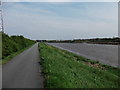
Dee Coastal Path towards Saltney Ferry
Looking along the Dee Coastal Path in the direction of the Saltney Ferry footbridge. The well surfaced path now provides a route all the way to Queensferry for cycling and walking.
Image: © John S Turner
Taken: 9 Mar 2008
0.08 miles
6
Borders 2 Industrial Estate 2
A view of the modern industrial boxes of the newest industrial estate development in the area.
Image: © Jonathan Wilkins
Taken: 19 Nov 2010
0.09 miles
7
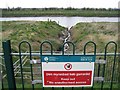
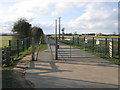
Drainage ditch into the River Dee
Like all other drainage ditches on this tidal section of the River Dee/Afon Dyfrdwy this unnamed one has a sluice gate mechanism to stop the high tides flooding the low lying land behind. The impressive 'Keep Out' sign is rendered pointless by the fact that there is nothing to stop you walking around the end of the railings. See Image
Image: © John S Turner
Taken: 4 Apr 2008
0.09 miles
8
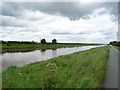
The River Dee
View from the Wales Coast Path.
Image: © JThomas
Taken: 15 Jun 2019
0.09 miles
9
River Dee and drainage ditch
One of many drainage ditches into the River Dee this unnamed one has a sluice gate to prevent high tides flooding the low lying land behind. The dangerous parts of the mechanism are totally enclosed by a metal grid structure, but the only restriction on stopping you walking around the end of the green railings to have a look is a sign telling you not to - see Image
Image: © John S Turner
Taken: 4 Apr 2008
0.09 miles
10
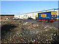
Borders 2 Industrial Estate 1
The industrial area of Saltney is vast, and divided into a number of individual estates. This is the most recent, with the rubble of pre-existing industrial space still bare after demolition.
Image: © Jonathan Wilkins
Taken: 19 Nov 2010
0.10 miles