IMAGES TAKEN NEAR TO
The Borders Industrial Park, River Lane, CHESTER, CH4 8RJ
Introduction
This page details the photographs taken nearby to The Borders Industrial Park, River Lane, CH4 8RJ by members of the Geograph project.
The Geograph project started in 2005 with the aim of publishing, organising and preserving representative images for every square kilometre of Great Britain, Ireland and the Isle of Man.

There are currently over 7.5m images from over14,400 individuals and you can help contribute to the project by visiting https://www.geograph.org.uk
Image Map
Images are licensed for reuse under creativecommons.org/licenses/by-sa/2.0
Notes
- Clicking on the map will re-center to the selected point.
- The higher the marker number, the further away the image location is from the centre of the postcode.
Image Listing (62 Images Found)
Images are licensed for reuse under creativecommons.org/licenses/by-sa/2.0
Image
Details
Distance
1
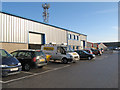
Borders 2 Industrial Estate 2
A view of the modern industrial boxes of the newest industrial estate development in the area.
Image: © Jonathan Wilkins
Taken: 19 Nov 2010
0.07 miles
2
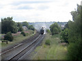
The Welsh Mountaineer approaching Mold Junction
The Welsh Mountaineer excursion to Blaenau Ffestiniog, hauled by 48151 Gauge O Guild LMS Stanier Class 8F, is seen here passing the end of St David's Terrace. The photo is taken from the Mold Junction bridge.
Image: © John S Turner
Taken: 11 Aug 2010
0.09 miles
3
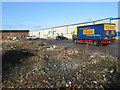
Borders 2 Industrial Estate 1
The industrial area of Saltney is vast, and divided into a number of individual estates. This is the most recent, with the rubble of pre-existing industrial space still bare after demolition.
Image: © Jonathan Wilkins
Taken: 19 Nov 2010
0.10 miles
5

A shy Goldfinch
Not the best photo of a Goldfinch (Carduelis carduelis), but perhaps representative of what a snapshot photographer (like me) can get whilst out for a walk, and it does prove that they live near the River Dee in Saltney.
Image: © John S Turner
Taken: 19 Sep 2015
0.11 miles
6
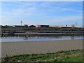
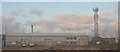
Looking across the Dee towards the Borders Industrial Park
Image: © Eirian Evans
Taken: 1 Mar 2012
0.11 miles
7
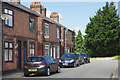
St David's Terrace, Saltney
This end of Saltney is called Saltney Ferry and St David's Terrace, a cul-de-sac which leads off Chester Road, includes a row of these unusual Victorian semi-detached houses. According to an estate agent's particulars for one of the houses (not in this view), they were 'understood to have been constructed by The Great Western Railway'. This seems surprising because, although the Great Western had a station in Saltney, these houses are much nearer the London & North Western Railway's line. Nevertheless, there is something about the architecture that is reminiscent of the Great Western's house style.
Image: © Stephen McKay
Taken: 14 Jun 2018
0.12 miles
8
Dee Coastal Path towards River Lane
The Dee Coastal Path keeps left here, but the right hand branch is for workers heading for one of the many industrial units on the right.
Image: © John S Turner
Taken: 9 Mar 2008
0.13 miles
9
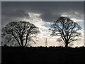
Saltney Ferry Electricity Pylon
Photographed from across the river, and from the very edge of the same square, the pylon stands guard over the Saltney Ferry electricity sub station. The two trees are on the line of the track from Higher Ferry to Mill Farm, which is on the banks of the River Dee.
Image: © John S Turner
Taken: 6 Dec 2006
0.13 miles
10
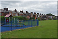
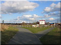
Rear of St David's Terrace, Saltney
The houses on St David's Terrace back on to the playing field belonging to St David's High School. A small children's recreation area has been sited in this corner of the field.
Image: © Stephen McKay
Taken: 14 Jun 2018
0.14 miles