IMAGES TAKEN NEAR TO
Argyll Avenue, CHESTER, CH4 8AL
Introduction
This page details the photographs taken nearby to Argyll Avenue, CH4 8AL by members of the Geograph project.
The Geograph project started in 2005 with the aim of publishing, organising and preserving representative images for every square kilometre of Great Britain, Ireland and the Isle of Man.

There are currently over 7.5m images from over14,400 individuals and you can help contribute to the project by visiting https://www.geograph.org.uk
Image Map
Images are licensed for reuse under creativecommons.org/licenses/by-sa/2.0
Notes
- Clicking on the map will re-center to the selected point.
- The higher the marker number, the further away the image location is from the centre of the postcode.
Image Listing (40 Images Found)
Images are licensed for reuse under creativecommons.org/licenses/by-sa/2.0
Image
Details
Distance
1
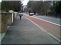
Hough Green, Looking towards Chester
The A5104 Hough Green Chester.
Image: © chestertouristcom
Taken: 3 Jan 2005
0.09 miles
2
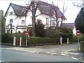
Hotel, Hough Green, Chester
One of the many Hotels on the A5104, Hough Green, Chester
Image: © chestertouristcom
Taken: 3 Jan 2005
0.09 miles
4
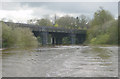
Railway Bridge, River Dee, Chester
The railway bridge across the tidal River Dee west of Chester city centre, between the Race Course and Curzon Park.
Image: © Martin Clark
Taken: Unknown
0.09 miles
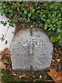
5
Boundary Stone in Curzon Park
This boundary stone is on the corner of Carrick Road at its junction with Earlsway. I don't know what the number three signifies. See also Image
Image: © John S Turner
Taken: 5 Apr 2009
0.12 miles
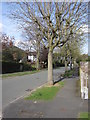
6
Earlsway and a boundary stone
Looking north-east along Earlsway, Curzon Park. On the left is a boundary stone that has an Ordnance Survey rivet bench mark - see Image The stone is between #53 and #55 Earlsway.
Image: © John S Turner
Taken: 15 Oct 2013
0.12 miles
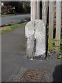
7
Boundary stone with rivet bench mark in Earlsway
This boundary stone is between #53 and #55 Earlsway, Curzon Park. There is an Ordnance Survey rivet in the top of the stone with the bench mark arrow on the face. See also Image Other nearby boundary stones are numbered, but the number on this one is unclear near ground level. For more details see the Bench Mark Database: http://www.bench-marks.org.uk/bm51924
Image: © John S Turner
Taken: 15 Oct 2013
0.12 miles
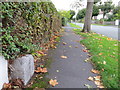
8
Earlsway in Curzon Park
A view of Earlsway in Curzon Park with a boundary stone on the right hand side of the photo. See also Image
Image: © John S Turner
Taken: 5 Apr 2009
0.13 miles
9
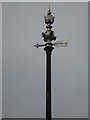
Sewer Vent Pipe, Curzon Park North, Chester
A splendid example of, I'm assuming, a cast iron sewer vent pipe in Curzon Park North. An arrow topped by a "divers helmet" topped by a crown, orb and pointy thing, excellent! This one was very high, was not worth photographing the surrounding houses and trees or the detail would have been lost. I wonder what the arrow is pointing to?
Image: © Sue Adair
Taken: 17 Dec 2006
0.13 miles
10
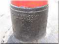
Manufacturer's name on the Georgian postbox in Curzon Park
The Georgian postbox in Earlsway, Curzon Park was made by the Carron Iron Works in Falkirk, Stirlingshire. The company was one of the largest in Europe and was in operation from 1759 to 1982. See also Image
Image: © John S Turner
Taken: 5 Apr 2009
0.13 miles