IMAGES TAKEN NEAR TO
Chantrell Road, WIRRAL, CH48 9XP
Introduction
This page details the photographs taken nearby to Chantrell Road, CH48 9XP by members of the Geograph project.
The Geograph project started in 2005 with the aim of publishing, organising and preserving representative images for every square kilometre of Great Britain, Ireland and the Isle of Man.

There are currently over 7.5m images from over14,400 individuals and you can help contribute to the project by visiting https://www.geograph.org.uk
Image Map (Loading...)


Getting Data...Please wait
Leaflet Map data © OpenStreetMap
Images are licensed for reuse under creativecommons.org/licenses/by-sa/2.0
Notes
- Clicking on the map will re-center to the selected point.
- The higher the marker number, the further away the image location is from the centre of the postcode.
Image Listing (8 Images Found)
Images are licensed for reuse under creativecommons.org/licenses/by-sa/2.0
Image
Details
Distance
1
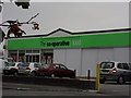
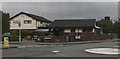
The Co-operative
Former Mitchell Skoda dealership, now converted to a mini supermarket, Frankby Road, Newton.
Image: © J Scott
Taken: 10 Oct 2010
0.05 miles
2
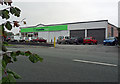
Good With Food
The Co-operative food store, Frankby Road, Newton.
Image: © J Scott
Taken: 10 Oct 2010
0.06 miles
4
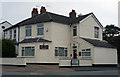
Springfield Dental Practice
Corner of Springfield Avenue and Frankby Road, Newton.
Image: © J Scott
Taken: 10 Oct 2010
0.10 miles
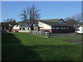
5
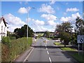
Frankby Road crossroads at Newton
China Farm Lane on left and Newton Cross Lane on right
Image: © Raymond Knapman
Taken: 30 Aug 2012
0.10 miles
8
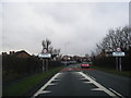
Entering Frankby on Frankby Road (B5139)
Heading south east.
Image: © JThomas
Taken: 1 Mar 2014
0.16 miles