IMAGES TAKEN NEAR TO
Black Horse Hill, WIRRAL, CH48 7EF
Introduction
This page details the photographs taken nearby to Black Horse Hill, CH48 7EF by members of the Geograph project.
The Geograph project started in 2005 with the aim of publishing, organising and preserving representative images for every square kilometre of Great Britain, Ireland and the Isle of Man.

There are currently over 7.5m images from over14,400 individuals and you can help contribute to the project by visiting https://www.geograph.org.uk
Image Map
Images are licensed for reuse under creativecommons.org/licenses/by-sa/2.0
Notes
- Clicking on the map will re-center to the selected point.
- The higher the marker number, the further away the image location is from the centre of the postcode.
Image Listing (19 Images Found)
Images are licensed for reuse under creativecommons.org/licenses/by-sa/2.0
Image
Details
Distance
1
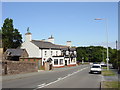
The Black Horse Inn, West Kirby
The Black Horse Inn, on Black Horse Hill, between West Kirby and Newton.
Image: © Sue Adair
Taken: 7 Aug 2006
0.02 miles
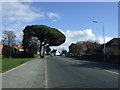
2
Black Horse Hill (B5139)
Towards Birkenhead.
Image: © JThomas
Taken: 1 Mar 2014
0.04 miles
3
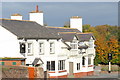
The Collingwood Bar and Restaurant
The Collingwood West Kirby
Image: © Steve Atkinson
Taken: 31 Oct 2007
0.07 miles
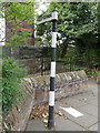
4
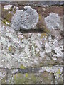
Ordnance Survey Cut Mark
This OS cut mark can be found on the wall at the junction of Column Road & Beacon Drive. It marks a point 55.580m above mean sea level.
Image: © Adrian Dust
Taken: 11 Apr 2016
0.13 miles
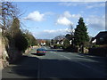
5
Hilbre View (A540)
Heading south west towards Heswall.
Image: © JThomas
Taken: 1 Mar 2014
0.13 miles
6
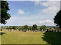
Grange Cemetery
Grange Cemetery between Lang Lane and Blackhorse Hill was opened after the First World War, the site was purchased in 1913.
Image: © Sue Adair
Taken: 3 Aug 2021
0.16 miles
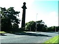
8
The Mariner's Column, Grange
This column was erected by the trustees of the Liverpool Docks by permission of John Shaw Leigh Esquire owner of the land who also granted the stone for the erection Anno Domini 1841 as a beacon for mariners frequenting the River Mersey and its vicinity
Erected as sighting line for vessels using the Hoyle lake and entering the Mersey. The column replaced a windmill that had similarly guided mariners.
Image: © Ian Greig
Taken: 30 Jun 2017
0.16 miles
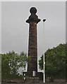
9
Direction Sign - Signpost by the A540, Column Road, Hoylake
Pawn finial - 1 arm; Wirral Footpath post by the A540, in parish of Hoylake (Wirral District), South West side of Column Road, immediately East of the huge Mariners' Column. Indicated footpath leads to Echo Lane.
Plate inscription reads:-
PUBLIC FOOTPATH
(TO ECHO LANE) overpainted.
Column inscription reads vertically:
(EREC)TED BY PERMISSION OF THE HIGHWAY AUTHORITY
Merseyside HER.
https://www.heritagegateway.org.uk/Gateway/Results_Single.aspx?uid=3314341&resourceID=1970
Surveyed
Milestone Society National ID: CH_SJ2286
Image: © John S Turner
Taken: 19 Sep 2016
0.17 miles
10
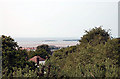
Rooftop & shrubbery
Hilbre Island can be seen with an incoming tide in the distance.
Image: © Row17
Taken: 15 Aug 2010
0.17 miles