IMAGES TAKEN NEAR TO
Meols Drive, WIRRAL, CH48 5JN
Introduction
This page details the photographs taken nearby to Meols Drive, CH48 5JN by members of the Geograph project.
The Geograph project started in 2005 with the aim of publishing, organising and preserving representative images for every square kilometre of Great Britain, Ireland and the Isle of Man.

There are currently over 7.5m images from over14,400 individuals and you can help contribute to the project by visiting https://www.geograph.org.uk
Image Map (Loading...)


Getting Data...Please wait
Leaflet Map data © OpenStreetMap
Images are licensed for reuse under creativecommons.org/licenses/by-sa/2.0
Notes
- Clicking on the map will re-center to the selected point.
- The higher the marker number, the further away the image location is from the centre of the postcode.
Image Listing (30 Images Found)
Images are licensed for reuse under creativecommons.org/licenses/by-sa/2.0
Image
Details
Distance
1
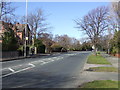
Meols Drive (A540)
Heading north towards Hoylake.
Image: © JThomas
Taken: 1 Mar 2014
0.03 miles
3
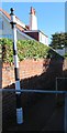
Old Direction Sign - Signpost by the A540, Meols Drive, Hoylake
Pawn finial - 1 arm; Wirral Footpath post by the A540, in parish of Hoylake (Wirral District), East side of Meols Drive, indicating an alley/footpath through to Graham Road.
No maker is visible, but it is in the style of the founders, Smiths of Whitchurch. The column bears the inscription:
"ERECTED BY THE WIRRAL FOOTPATHS ETC. SOCIETY WITH CONSENT OF THE COUNTY COUNCIL"
Surveyed
Milestone Society National ID: CH_SJ2187
Image: © John S Turner
Taken: 2 Oct 2016
0.06 miles
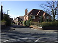
5
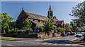
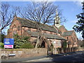
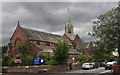
St Andrews Church
St Andrews Church in West Kirkby.
Image: © Peter McDermott
Taken: 25 May 2017
0.13 miles
9
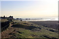
West Kirby from Red Rocks Marsh
View towards West Kirby from Red Rocks Marsh SSSI.
Cheshire Wildlife Trust http://www.cheshirewildlifetrust.org.uk/reserves/red-rocks-marsh
Image: © Jeff Buck
Taken: 24 Nov 2016
0.17 miles
10
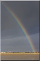
Rainbow near West Kirby
A rainbow viewed over the Wirral peninsula between Hoylake and West Kirby - cloud, sun and high wind have combined to create lighting conditions that change from moment to moment. I scarcely had the time to photograph this rainbow before it disappeared as the wind shifted the cloud cover, obscuring the sun.
Image: © William Starkey
Taken: 15 Dec 2014
0.18 miles