IMAGES TAKEN NEAR TO
Norton Road, WIRRAL, CH48 5EU
Introduction
This page details the photographs taken nearby to Norton Road, CH48 5EU by members of the Geograph project.
The Geograph project started in 2005 with the aim of publishing, organising and preserving representative images for every square kilometre of Great Britain, Ireland and the Isle of Man.

There are currently over 7.5m images from over14,400 individuals and you can help contribute to the project by visiting https://www.geograph.org.uk
Image Map
Images are licensed for reuse under creativecommons.org/licenses/by-sa/2.0
Notes
- Clicking on the map will re-center to the selected point.
- The higher the marker number, the further away the image location is from the centre of the postcode.
Image Listing (60 Images Found)
Images are licensed for reuse under creativecommons.org/licenses/by-sa/2.0
Image
Details
Distance
1
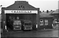
Crosville Motor Services garage, West Kirby ? 1971
Crosville was one of the largest of the companies to be nationalised in 1948. It covered the whole of North Wales and Cheshire, much of western mid-Wales and parts of Shropshire, Staffordshire and Merseyside. The West Kirby Garage was a typical small garage (there was a second shed to the left) built in the interwar period. It has since disappeared, the area now being given over to housing.
This is one of a series of views featuring buses in the 60s, 70s, and 80s. http://www.geograph.org.uk/search.php?i=137652761
Image: © Alan Murray-Rust
Taken: 6 Feb 1971
0.04 miles
2
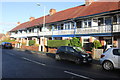
Orrysdale Road, West Kirby
These unusual looking terraced houses in Orrysdale Road have a narrow balcony on the upstairs floors.
Image: © Jeff Buck
Taken: 24 Nov 2016
0.06 miles
3
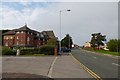
Orrysdale Road
Looking along Orrysdale Road in West Kirby.
Image: © DS Pugh
Taken: 15 Sep 2014
0.06 miles
4
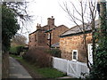
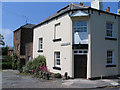
Willow Cottage, West Kirby
Willow Cottage, also known as the Red House as it is constructed entirely of local red sandstone blocks, is one of the oldest houses in West Kirby.
Image: © Sue Adair
Taken: 30 Jan 2008
0.10 miles
5
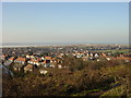
View from Grange Hill
View from Grange Hill over West Kirby towards the Royal Liverpool Golf links and Hoylake in the distance and beyond to the Irsh sea, the outline of Hilbre Island is to the left.
Image: © Sue Adair
Taken: 29 Jan 2006
0.12 miles
6
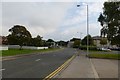
Looking along Orrysdale Road
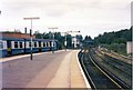
Looking towards the petrol station near West Kirby station.
Image: © DS Pugh
Taken: 15 Sep 2014
0.12 miles
7
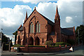
Reform Church at junction of Moel Drive & Bridge Road
Image: © Row17
Taken: 14 Aug 2010
0.13 miles
8
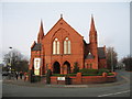
West Kirby United Reformed Church, Meols Drive.
Image: © Sue Adair
Taken: 30 Jan 2008
0.13 miles
10
De Grouchy Street
De Grouchy Street (on the left) is the only 'Street' in West Kirby.
Image: © Peter Craine
Taken: 7 Jun 2006
0.13 miles