IMAGES TAKEN NEAR TO
The Finney, WIRRAL, CH48 2LL
Introduction
This page details the photographs taken nearby to The Finney, CH48 2LL by members of the Geograph project.
The Geograph project started in 2005 with the aim of publishing, organising and preserving representative images for every square kilometre of Great Britain, Ireland and the Isle of Man.

There are currently over 7.5m images from over14,400 individuals and you can help contribute to the project by visiting https://www.geograph.org.uk
Image Map (Loading...)


Getting Data...Please wait
Leaflet Map data © OpenStreetMap
Images are licensed for reuse under creativecommons.org/licenses/by-sa/2.0
Notes
- Clicking on the map will re-center to the selected point.
- The higher the marker number, the further away the image location is from the centre of the postcode.
Image Listing (14 Images Found)
Images are licensed for reuse under creativecommons.org/licenses/by-sa/2.0
Image
Details
Distance
1
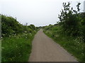
The Wirral Way towards West Kirby
Looking north west on a disused railway.
Image: © JThomas
Taken: 25 May 2019
0.04 miles

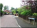
3

Bridge over the Wirral Way
Looking south east on a disused railway.
Image: © JThomas
Taken: 25 May 2019
0.08 miles
4

Caldy Golf Course
View towards the Dee Estuary.
Image: © JThomas
Taken: 25 May 2019
0.08 miles


9
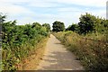
The Wirral Way at Caldy
The Wirral Way heading south at Caldy.
Wikipedia http://en.wikipedia.org/wiki/Wirral_Country_Park
Image: © Jeff Buck
Taken: 26 Jul 2013
0.21 miles
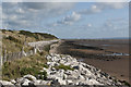
10
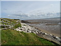
Beach access at Caldy Blacks
Low tide in the Dee Estuary.
Image: © John M
Taken: 9 Jun 2017
0.21 miles