IMAGES TAKEN NEAR TO
Caldy Road, WIRRAL, CH48 2LB
Introduction
This page details the photographs taken nearby to Caldy Road, CH48 2LB by members of the Geograph project.
The Geograph project started in 2005 with the aim of publishing, organising and preserving representative images for every square kilometre of Great Britain, Ireland and the Isle of Man.

There are currently over 7.5m images from over14,400 individuals and you can help contribute to the project by visiting https://www.geograph.org.uk
Image Map (Loading...)


Getting Data...Please wait
Leaflet Map data © OpenStreetMap
Images are licensed for reuse under creativecommons.org/licenses/by-sa/2.0
Notes
- Clicking on the map will re-center to the selected point.
- The higher the marker number, the further away the image location is from the centre of the postcode.
Image Listing (19 Images Found)
Images are licensed for reuse under creativecommons.org/licenses/by-sa/2.0
Image
Details
Distance
5
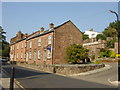
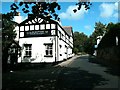
The Old Village, West Kirby
Sandstone cottages in Village Rd, West Kirby
Image: © Sue Adair
Taken: 17 Aug 2005
0.06 miles
6
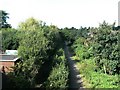
Trackbed of West kirby to Hooton railway
The trackbed is now a linear park
Image: © Raymond Knapman
Taken: 9 Sep 2009
0.10 miles
7
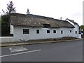
The Nook
Late 17th century thatched cottage on Village Road.
Image: © Eirian Evans
Taken: 17 May 2016
0.11 miles
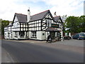
10
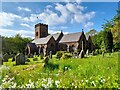
St Bridget's, West Kirby
A most handsome building both inside and out.
Image: © David Bremner
Taken: 12 May 2023
0.14 miles