IMAGES TAKEN NEAR TO
Kings Drive, WIRRAL, CH48 2JH
Introduction
This page details the photographs taken nearby to Kings Drive, CH48 2JH by members of the Geograph project.
The Geograph project started in 2005 with the aim of publishing, organising and preserving representative images for every square kilometre of Great Britain, Ireland and the Isle of Man.

There are currently over 7.5m images from over14,400 individuals and you can help contribute to the project by visiting https://www.geograph.org.uk
Image Map (Loading...)


Getting Data...Please wait
Leaflet Map data © OpenStreetMap
Images are licensed for reuse under creativecommons.org/licenses/by-sa/2.0
Notes
- Clicking on the map will re-center to the selected point.
- The higher the marker number, the further away the image location is from the centre of the postcode.
Image Listing (30 Images Found)
Images are licensed for reuse under creativecommons.org/licenses/by-sa/2.0
Image
Details
Distance
1
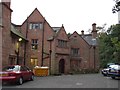
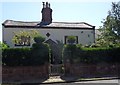
Caldy Manor Residential Home
Main entrance to the home and car park.
Image: © Alex Passmore
Taken: 15 Oct 2004
0.17 miles
2
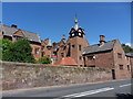
Caldy Manor and Mews
Manor with Timber framed top stage having clock faces and open work panels and on gables to all sides. Caldy Mews adjoins at this West side of the Manor.
Image: © J Scott
Taken: 5 Aug 2011
0.18 miles
3
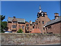
Caldy Manor
Original building constructed in 17th Century. Now the house is an old people's home.
Image: © J Scott
Taken: 5 Aug 2011
0.18 miles
4

Old Boundary Marker
Municipal Boundary Marker protruding from the base of a National Trust stone boundary wall 2 metres south of a public footpath on the northwest side on Caldy Hill. Wirral metropolitan district. Inscribed Caldy / 36. Possibly used to mark the boundary of Caldy township by the Barton Family.
Milestone Society National ID: CH_CALD36pb
Image: © J Watt
Taken: 14 Apr 2020
0.19 miles
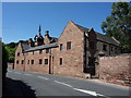
6
Manor Farmhouse
100 Caldy Road, Caldy. Formerly known as the Dower House. Dated 1683", apparently renovated in 1830s by R. B. Rampling.
Image: © J Scott
Taken: 5 Aug 2011
0.20 miles
7
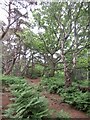
Woodland, Caldy Hill
Typical sandstone woodland which you can find between here and Worcester.
Image: © Richard Webb
Taken: 26 May 2022
0.20 miles
8
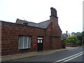
House on the B5140, Caldy
Showing position of Postbox No. CH48 52.
Image: © JThomas
Taken: 25 May 2019
0.20 miles
9
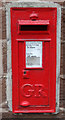
George V postbox on the B5140, Caldy
Postbox No. CH48 52.
Image: © JThomas
Taken: 25 May 2019
0.20 miles
10

Caldy Hill Panorama
This is the wonderful view from Caldy Hill taken on the first day of practice when the British Golf Open was played at Hoylake (course this side of the white lighthouse).
Image: © William Bartlett
Taken: 17 Jul 2006
0.20 miles