IMAGES TAKEN NEAR TO
Caldy Road, WIRRAL, CH48 2HX
Introduction
This page details the photographs taken nearby to Caldy Road, CH48 2HX by members of the Geograph project.
The Geograph project started in 2005 with the aim of publishing, organising and preserving representative images for every square kilometre of Great Britain, Ireland and the Isle of Man.

There are currently over 7.5m images from over14,400 individuals and you can help contribute to the project by visiting https://www.geograph.org.uk
Image Map (Loading...)


Getting Data...Please wait
Leaflet Map data © OpenStreetMap
Images are licensed for reuse under creativecommons.org/licenses/by-sa/2.0
Notes
- Clicking on the map will re-center to the selected point.
- The higher the marker number, the further away the image location is from the centre of the postcode.
Image Listing (21 Images Found)
Images are licensed for reuse under creativecommons.org/licenses/by-sa/2.0
Image
Details
Distance
1
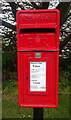
Close up, Elizabeth II postbox on Melloncroft Drive, Caldy
Postbox No. CH48 63.
Image: © JThomas
Taken: 25 May 2019
0.08 miles
2
Elizabeth II postbox on Melloncroft Drive, Caldy
Postbox No. CH48 63.
Image: © JThomas
Taken: 25 May 2019
0.08 miles
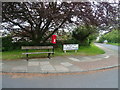
3

Wall, Caldy Hill
Woodland which avoided becoming a garden to a big house.
Image: © Richard Webb
Taken: 26 May 2022
0.09 miles
4

Old Boundary Marker
Municipal Boundary Marker protruding from the base of a National Trust stone boundary wall 2 metres south of a public footpath on the northwest side on Caldy Hill. Wirral metropolitan district. Inscribed Caldy / 36. Possibly used to mark the boundary of Caldy township by the Barton Family.
Milestone Society National ID: CH_CALD36pb
Image: © J Watt
Taken: 14 Apr 2020
0.10 miles

6
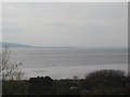
The Dee Estuary and across to North Wales from Caldy Hill
Image: © David Jones
Taken: 13 Apr 2009
0.10 miles
7
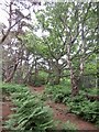
Woodland, Caldy Hill
Typical sandstone woodland which you can find between here and Worcester.
Image: © Richard Webb
Taken: 26 May 2022
0.11 miles
10
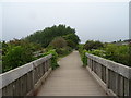
Bridge on the Wirral Way, Cubbins Green
Looking north west on a disused railway.
Image: © JThomas
Taken: 25 May 2019
0.19 miles