IMAGES TAKEN NEAR TO
Caldy Road, WIRRAL, CH48 2HW
Introduction
This page details the photographs taken nearby to Caldy Road, CH48 2HW by members of the Geograph project.
The Geograph project started in 2005 with the aim of publishing, organising and preserving representative images for every square kilometre of Great Britain, Ireland and the Isle of Man.

There are currently over 7.5m images from over14,400 individuals and you can help contribute to the project by visiting https://www.geograph.org.uk
Image Map
Images are licensed for reuse under creativecommons.org/licenses/by-sa/2.0
Notes
- Clicking on the map will re-center to the selected point.
- The higher the marker number, the further away the image location is from the centre of the postcode.
Image Listing (62 Images Found)
Images are licensed for reuse under creativecommons.org/licenses/by-sa/2.0
Image
Details
Distance
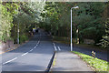

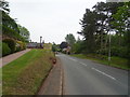
3
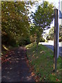
Public Bridleway
Leading to Shore Road, the pathway leads off the B5140 Caldy Road, Caldy Village.
Image: © J Scott
Taken: 5 Aug 2011
0.12 miles

6
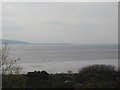
The Dee Estuary and across to North Wales from Caldy Hill
Image: © David Jones
Taken: 13 Apr 2009
0.14 miles
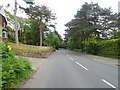
7
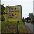
Pre-Worboys road sign on the Caldy Road (B5141), Caldy
Image: © JThomas
Taken: 25 May 2019
0.14 miles
9
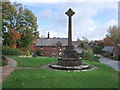
Cross at Caldy village green
Cross was erected to the memory of Alfred Barton 'by many who loved him'.
Image: © Adie Jackson
Taken: 29 Oct 2007
0.15 miles
10
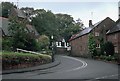
Caldy
Attractive village on the B5140 south of West Kirby
Image: © Rosalind Mitchell
Taken: 19 Oct 2002
0.15 miles