IMAGES TAKEN NEAR TO
Caldy Road, WIRRAL, CH48 2AA
Introduction
This page details the photographs taken nearby to Caldy Road, CH48 2AA by members of the Geograph project.
The Geograph project started in 2005 with the aim of publishing, organising and preserving representative images for every square kilometre of Great Britain, Ireland and the Isle of Man.

There are currently over 7.5m images from over14,400 individuals and you can help contribute to the project by visiting https://www.geograph.org.uk
Image Map
Images are licensed for reuse under creativecommons.org/licenses/by-sa/2.0
Notes
- Clicking on the map will re-center to the selected point.
- The higher the marker number, the further away the image location is from the centre of the postcode.
Image Listing (14 Images Found)
Images are licensed for reuse under creativecommons.org/licenses/by-sa/2.0
Image
Details
Distance
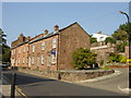
2
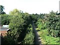
Trackbed of West kirby to Hooton railway
The trackbed is now a linear park
Image: © Raymond Knapman
Taken: 9 Sep 2009
0.10 miles
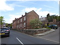
6
The Old Village, West Kirby
Sandstone cottages in Village Rd, West Kirby
Image: © Sue Adair
Taken: 17 Aug 2005
0.17 miles
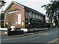
8

Tell's Tower, West Kirby
For those who notice the name Tell's Tower on the map near to the marine lake in West Kirby and wonder who Tell may have been:-
Tell was a dog who died saving his master from drowning on 22nd January 1871 aged seven years. The small round sandstone tower was built in recognition of the dog's bravery by the Rev. John Cumming Macdona in the grounds of his residence Hilbre House. At the base of the tower there is an inscription and carving of the dog, unfortunately much deteriorated due to weathering of the soft sandstone. The tower was used as a look-out post in WWII and Hilbre House, demolished last century, was also once the home of Selwyn Lloyd. A number of houses were built on the site and the tower incorporated into one of them so that access is no longer possible.
Image: © Sue Adair
Taken: 17 Aug 2005
0.20 miles
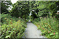
9
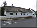
The Nook
Late 17th century thatched cottage on Village Road.
Image: © Eirian Evans
Taken: 17 May 2016
0.22 miles